Route Editor

| Guide | ♦ | 10 Triplogs | 1 Topic |
details | drive | permit | forecast | map |
stats |
photos | triplogs | topic | location |
| 237 | 10 | 1 |
Canyons are inherently risky. Flash floods occur without notice on sunny days. Technical skills & surrounding topography knowledge required yet does not eliminate risk.
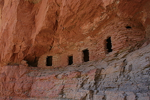
Rafting Arizona by JimmyLyding  This compilation of hikes was completed during a rafting trip down the Colorado River through the Grand Canyon. We did the trip with Colorado River And Trails Expeditions (CRATE). We started at Lee's Ferry on Friday July 13, 2007. Our first night's camp was just downriver from Nautiloid Canyon (just before Mile 35). Our first hike was on the second day and was a short hike from the campsite to Nautiloid Canyon. The total mileage for this hike was less than a mile. We had to do some mild bouldering to get into the canyon. The highlight was probably seeing nautiloid fossils. This compilation of hikes was completed during a rafting trip down the Colorado River through the Grand Canyon. We did the trip with Colorado River And Trails Expeditions (CRATE). We started at Lee's Ferry on Friday July 13, 2007. Our first night's camp was just downriver from Nautiloid Canyon (just before Mile 35). Our first hike was on the second day and was a short hike from the campsite to Nautiloid Canyon. The total mileage for this hike was less than a mile. We had to do some mild bouldering to get into the canyon. The highlight was probably seeing nautiloid fossils.Later on the second day, we got to Nankoweap Canyon (just past Mile 52), where we hiked to the granaries which ancient Native Americans used to store grain. The hike left the river through a thick bosque of mesquite trees and reeds. Shortly after leaving the river, the trail begins a steep ascent. The 1 mile or so hike from the river up to the granaries is about as steep as they come. However, the payoff is incredible. Not only are there ancient granaries, but the view downriver is superb.
We camped the second night at the mouth of Lava Canyon (just past Mile 65). We shuttled back upriver on the third morning to Carbon Creek Canyon. We hiked up Carbon Creek Canyon, where we got to experience some mild bouldering on the way up to a great view of the North Rim. The views of the Grand Canyon's fantastic geology were on full display. This hike is commonly called the Lava-Chuar loop as it makes a circumference of Chuar Lava Hill. The hike totaled about 4 miles. It was slightly strenuous on the way up Carbon Creek Canyon and an easy downhill hike, down Lava Canyon back to our campsite. On the third day, we also hiked up to Phantom Ranch in Bright Angel Canyon. While not much of a hike, it allowed us to see one of the more historic areas of the Grand Canyon. Saw a lot of tenderfeet hanging in the Bright Angel Lodge drinking ice-cold drinks as-opposed-to lukewarm Old Styles. On the fourth day, we did a hike commonly called the Monument-Hermit loop. We hiked from the river up Monument Creek Canyon up to a high point separating that drainage from Hermit Creek Canyon. We then hiked down Hermit Creek Canyon to a small waterfall where we got to cool off. We then finished the hike by continuing down Hermit Creek Canyon to the river to enjoy going through Hermit Rapid, the first big rapid of the trip. On the fifth day, we hiked up Elves' Chasm. While not much of a hike in terms of how strenuous it is, it did involve some mild bouldering. Leaping into Elves' Chasm was one of the highlights of the trip. The sixth day was the vaunted "Death March." We started very early up Tapeats Creek from the river. We hiked up Tapeats Creek to its junction w/ Thunder River. We then hiked up to Thunder River on a fairly steep trail. Thunder River starts @ a monumental surge of water right out of the canyon wall. It's a lovely spot. From there, we hiked up a fairly steep trail into Surprise Valley. Surprise Valley has exactly one spot of shade from that point to all of the way into Deer Creek Canyon. Soon after hiking into Deer Creek Canyon, we got to Dutton Spring, which also gushes straight out of the canyon wall on its way to join Deer Creek. At Deer Creek, there is an area affectionally called the "Patio." It's a nice place to cool off after the Death March and an even nicer spot to enjoy lunch. From the Patio, it's a steep descent down to the river and Deer Creek Falls. All told, the Death March was about 11 miles in lots of heat and sun. The seventh day marked our visit to Havasu Creek. Again, while not much of a hike, we got to experience a lot of fun in the water. Lots of people from other tours were there. After that, we did Lava Falls and partied on the last night. The eighth and last day involved traveling via boat, helicopter, plane, and automobile. There aren't too many days when one can say they've done that. Check out the Triplogs. Leave No Trace and +Add a Triplog after your canyon trip to support this local community. | ||||||||||||||||||||||||||||||||||||||||||||||||||||||||||||||||||||||||||||||||||||||||||||||||||