Route Editor

| Guide | ♦ | 2 Triplogs | 0 Topics |
details | drive | no permit | forecast | route |
stats |
photos | triplogs | topics | location |
| 32 | 2 | 0 |
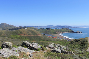
High Ridge Between Pacific Ocean and Golden Gate by JimmyLyding This hike begins at the end of Mitchell Road which ends at the trailhead. There is ample parking, but a lot of it is used by beachgoers visiting the adjacent Rodeo Beach. Rodeo Beach is popular with surfers, but is poorly suited for swimming due to its steep grade and consistent undercurrent. The trailhead is right at the end of the road on the lower part of the bluff that marks Rodeo Beach's northern boundary, and is adorned with the usual California signage: mountain lion warning, steep cliff warning, tick warning, etc. Take the Coastal Trail uphill to the north while ignoring the side trail on the left to Tennessee Point. You may be tempted to head out to Tennessee Point for a view, but having enough views will not be a problem on this hike.
Of course you want to summit the mountain you've been climbing so turn right to follow the signs to Hill 88 only a short bit away. The top of Hill 88 is an old military installation that used to have a radar station and communication gear. Now it has the shells of buildings painted avocado-green and a few concrete pads. There is a short trail that continues east from the top, but ends at another cluster of buildings. Bushwhacking down to the Wolf Ridge Trail, which you must get to, is impossible due to a serious fence. To reach that trail you must head back the way you came and west down from the peak to the junction. Turn right/east onto the Wolf Ridge Trail for some more cardio as the trail drops about 350' feet over an up-and-down grade to a saddle with the Miwok Trail headed due north and to the southeast. Turn left/north onto the Miwok Trail for a mellow jaunt above the upper portion of Tennessee Valley for 1/3 mile before enjoying a 400' ascent to the top of peak while ignoring the Old Springs Trail branching off to the north 1/3 mile up. This peak features some sort of equipment used for aircraft navigation, and there are stern warnings against entry posted all over the well-maintained fence. This peak also has superb views in all directions. Interestingly enough it seemed warmer up on the peaks than it did closer to sea-level when I did this hike in April 2012. Return the way you came back down the mountain on the Miwok Trail and keep heading straight/south/downhill on the same trail. Miwok drops about 600' over a mile and change on a smooth fire road. You walk down through the same chaparral you've enjoyed the entire hike to a junction with a signed trail to Rodeo Beach. Take that trail as it heads due west along a large creek, and reach a large building resembling a warehouse. There is a parking area here, and looks like a fine parking spot. The trail also parallels Mitchell Road as it heads to Fort Cronkhite and the numerous parking spots. Check out the Official Route and Triplogs. Leave No Trace and +Add a Triplog after your hike to support this local community. | ||||||||||||||||||||||||||||||||||||||||||||||||||||||||||||||||||||||||||||||||||||||||