 Route Editor

| Guide | ♦ | 1 Triplog | 0 Topics |
details | drive | permit | forecast | route |
stats |
photos | triplog | topics | location |
| 12 | 1 | 0 |
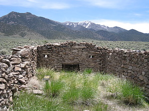
Not Your Average Trail Ride by AZLOT69  It only lasted from April 1860 - October 1861 but the Pony Express was an important part of western U.S history and folklore. As a privately owned business it was no bargain as they charged as much as five dollars an ounce to deliver. Even at that, they never made a profit. They also never received any assistance financially from the government. The stations were built from 10-35 miles apart. The location was not picked for safety or convenience but for building materials at hand and water availability. The Cold Springs structure is one of the best preserved Pony Express Stations quite possibly because of its remote location. It is quite large being 116 feet by 51 feet and constructed of large rocks and mud. These stations were prime for Indian attacks so they were heavily fortified. The walls are 4-6 feet tall and three feet thick and contain gun ports. The station was divided into four rooms, storage, barn, corral, and living quarters. The horses were kept next to the living quarters due to their value and heat their bodies provided on cold desert nights. Hike About twelve miles east of U.S. 50 and SR 361 there are ruins visible off the north side of the highway. This is an old telegraph station and it is surrounded by fence with no access. Just east of here on the south side of the street is a kiosk and pit restroom. This is the trailhead for the Cold Springs Pony Express Station. For as far as you can see there is sage, scrub brush and tumbleweed in all directions. You can see for more than the signs stated two miles to the ruins, so where are they. Certainly you can see them from here. Not a chance. Built with native materials it just blends into the environment. The trail starts off in an easterly direction. It has been lined with surrounding rocks at various locations where animal trails cross to keep you on the right track. The trail gets little use and there were several times I was unsure this was even a trail but about a mile in you see what appears to be a rock outcropping on the horizon and sure enough as that rock outcropping comes closer it becomes apparent it is man made. There were many black tailed jack rabbits encountered as well as several curious lizards darting about. Arriving at the Pony Express Station you first notice a stream of cold clean water passing very close to the structure. Surrounded by fence to keep people orderly there is an entry way and register. People are requested to stay off the structures but you have full access. There is a single fireplace in the living quarters and several gun ports all around the station. As I was, you may be inclined to explore the area further and when you have satisfied your curiosity return the way you came. Check out the Official Route and Triplog. Leave No Trace and +Add a Triplog after your hike to support this local community. One-Way Notice This hike is listed as One-Way. When hiking several trails on a single "hike", log it with a generic name that describes the hike. Then link the trails traveled, check out the example. | ||||||||||||||||||||||||||||||||||||||||||||||||||||||||||||||||||||||||||||||||||||||||


