username
X
password
register
for free!
help
  This is likely a great time to hike this trail!  Check out "Preferred" months below, keep in mind this is an estimate.
  🔥

Overland Trail, AZ

Guide 24 Triplogs  1 Topic
  3 of 5  
Fav
Wish
0
details
drive
no permit
forecast
🔥
route  
stats
photos
triplogs
topic
location
119 24 1
Statistics
tap row or icons for details
Distance One Way 17.5 miles
Trailhead Elevation 9,078 feet
feature photo
Photos Viewed All MineFollowing
Will recalculate on button tap!
6  2023-08-23 jonathanpatt
23  2011-08-28
Overland Trl to Water Canyon Trl Head
AZ_Jim1
20  2011-08-27 beiley
15  2010-07-09 azbackpackr
13  2010-04-24 azbackpackr
4  2010-01-22
Water Canyon Road
azbackpackr
15  2009-08-01
Water Canyon to Sipe
azbackpackr
7  2009-04-25
Upper South Fork
azbackpackr
Page 1,  2
Author
author avatar Guides 16,843
Routes 17,472
Photos 24
Trips 1 map ( 6 miles )
Age 28 Male Gender
Location HAZ, TrailDEX
Associated Areas
list map done
Alpine Region
Historical Weather
Trailhead Forecast
Radar Map
Expand Map
Preferred Aug, Sep, Jun, Jul → 7 AM
Sun  5:54am - 6:38pm
Official Route & 3 Rts
 
0 Alternative
 
Historic Fire Perimetersacres
🔥 2011 Wallow Fire29
🔥 2004 Three Forks Fire22.4 mi*
🔥 1971 Trag Fire17.5 mi**
🔥 1971 Phone2.8 mi*
🔥 View (All) - over Official Route 🔥
*perimeter length in miles
**possible voids inflate figure


remove free decal offer

  Likely In-Season!
Guide Needed
Publish Full Detail Guide


Use +Add above to share photos and triplogs
The Overland Trail travels northeast from Crescent Lake through very diverse landscapes including forested terrain and open, high elevation grasslands and provides beautiful vistas.
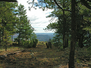


    Check out the Official Route and Triplogs.
    Leave No Trace and +Add a Triplog after your hike to support this local community.

    One-Way Notice
    This hike is listed as One-Way.

    When hiking several trails on a single "hike", log it with a generic name that describes the hike. Then link the trails traveled, check out the example.
    WARNING! Hiking and outdoor related sports can be dangerous. Be responsible and prepare for the trip. Study the area you are entering and plan accordingly. Dress for the current and unexpected weather changes. Take plenty of water. Never go alone. Make an itinerary with your plan(s), route(s), destination(s) and expected return time. Give your itinerary to trusted family and/or friends.

     Permit $$
    None


     Directions
    or
     Road
    Paved - Car Okay

    To hike
     90+° 8am - 6pm kills
    helpcorrectionissue

    end of page marker