Route Editor

| Guide | ♦ | 6 Triplogs | 0 Topics |
details | drive | permit | forecast | route |
stats |
photos | triplogs | topics | location |
| 68 | 6 | 0 |
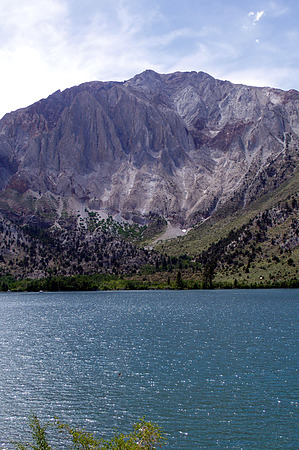
majestic background by slegal So how did Convict Lake get its name? In 1871 three prisoners at the Carson City State Penitentiary escaped. The three fugitives were confronted by Robert Morrison, a local merchant and posse member, at Monte Diablo Creek, later renamed Convict Creek. Morrison was killed in the confrontation. Mount Morrison is named after Robert Morrison.
Finding the trail is simple. Walk along the lake in either direction and when the pavement ends the trail begins. As far as hikes go, this is an easy one. Total mileage is 2.5 miles. The trail is very flat with only 40 feet of elevation gain. Most of the trail is in the sun. There are very few trees along the route except for sparse trees on the east side and more trees where convict creek empties in the Convict Lake. One interesting part of the hike is where convict creek flows into the lake. The water level is frequently high and widely dispersed, so the forest service built and elevated boardwalk over the creek. From photos I posted on the hike you can see that the trail would have been impassible, since the creek was flooding. The base of the aspens in one of my photos were all under water. Check out the Official Route and Triplogs. Leave No Trace and +Add a Triplog after your hike to support this local community. | ||||||||||||||||||||||||||||||||||||||||||||||||||||||||||||||||||||||||||||||||||||||||||||