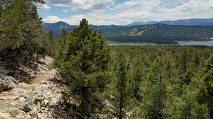
A well-maintained path through a wide variety of natural environments distinguishes the Cougar Crest. It starts 0.6 of a mile west of the Discovery Center on HWY 38. (You can park for free until 5:00 pm at the Big Bear Discovery Center and walk the 0.6 mile to the trailhead.) In the first mile there’s only a gentle uphill increase, but within the second mile you’ll realize that you’re gaining serious altitude. The Cougar Crest Trail ends at the junction of the Pacific Crest Trail (No bicycles on PCT).
To Bertha Peak: Continue east (right) on the Pacific Crest Trail to a dirt maintenance road. Continue 0.6 on maintenance road until you reach the summit of Bertha Peak (8,201 feet); easily recognized by the large collection of communication equipment at the top. From the summit there’s a near 360 degree view of the Bear Valley, Holcomb Valley, even the Mojave Desert.
When hiking several trails on a single "hike", log it with a generic name that describes the hike. Then link the trails traveled, check out the example.
WARNING! Hiking and outdoor related sports can be dangerous. Be responsible and prepare for the trip. Study the area you are entering and plan accordingly. Dress for the current and unexpected weather changes. Take plenty of water. Never go alone. Make an itinerary with your plan(s), route(s), destination(s) and expected return time. Give your itinerary to trusted family and/or friends.
Permit $$
no fees or permits reported
if incorrect tell us about it
San Bernadino Forest Visit the San Bernadino Passes & Permits for current information
Directions
Road
To hike
page created by HAZ_Hikebot on Mar 09 2010 11:45 pm
 Route Editor


