Route Editor

| Guide | ♦ | 4 Triplogs | 0 Topics |
details | drive | no permit | forecast | route |
stats |
photos | triplogs | topics | location |
| 20 | 4 | 0 |
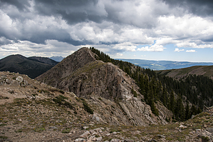
perfect for me by slegal The hike starts the same way that a hike to Nambe Lake starts. Park in the lot at Ski Santa Fe and head over to the Winsor Trail at the northwest corner of the parking lot. From the trailhead head northeast up a series of switchbacks until you get to the Pecos Wilderness Boundary fence. ThIf you go through the gate at the fence you can get to Nambe Lake, Santa Fe Baldy and many other places. To get to Deception Peak you turn right at the fence and head up along the fence. Total distance to the fence is 0.8 miles
The initial climb is fairly gentle heading pretty much straight along the wilderness boundary fence for about 0.8 miles. The fence is lined with barbed wire and at points the trail hugs the fence, so try to avoid scratching yourself on the fence. The trail then turns to the right and head south. At the turn there is a great view spot overlooking the canyon that heads up to Nambe Lake. You’re not quite high enough yet to see Nambe Lake. From the same vantage point there are some great views of Santa Fe Baldy, a 12,621 foot peak to the northeast. The trail is now quite a bit steeper. It also splits into multiple trails at point, but all of these trails seem to meet back up. There are two intermediate peaks that you reach during the climb. Shortly before the first peak you arrive a field of large boulders. I saw lots of Rocky Mountain Columbine in this boulder field. If you want to see the Columbine, stay it the rougher section of the boulder field. The easiest way to get through the boulder field is to stay as far to the left as possible. My GPS said that the top of the first peak was about 11,750’. After cresting the first peak you lose to elevation heading down the other side. My GPS said it was about a 60 foot descent. Then you begin the climb to the second intermediate peak. The second intermediate peak tops out at about 12,000’ before dropping about 110’ down the other side. From the saddle between the second intermediate peak and Deception Peak, you pass the tree line and head up a steep bare slope toward a ridgeline, when you reach the ridgeline turn left and head up to the summit. The deception in the name Deception Peak is that when you reach the summit, you realize that you’re not at the highest point along the ridgeline. The highest point is Lake Peak to the northeast. I have a fear of heights and the route to Lake Peak is more than I’m willing to take on. Deception Peak was perfect for me. The route we took down varied from the route up. We headed back down to the saddle between the summit at the second intermediate peak. There is a cairn marking a steep trail down to an access road within the ski area. This is a more direct and smoother trail which will get you down the mountain quicker when the typical afternoon thunderstorms hit. Gate Policy: If a gate is closed upon arrival, leave it closed after you go through. If it is open, leave it open. Leaving a closed gate open may put cattle in danger. Closing an open gate may cut them off from water. Please be respectful, leave gates as found. The exception is signage on the gate directing you otherwise. Check out the Official Route and Triplogs. Note This is a moderately difficult hike. Leave No Trace and +Add a Triplog after your hike to support this local community. | |||||||||||||||||||||||||||||||||||||||||||||||||||||||||||||||||||||||||||||||||||||||||||||