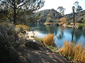
Finding the trailhead to this hike is half the battle, and the other half is trying to figure out, among the many shoreline trails, which one is the loop trail. I found a trailhead with confusing signage near the entrance station. Park in the lot provided for the Jack Creek picnic area with playground equipment on the left just after passing the entrance booth. There is a trail sign and a trail kiosk on the north end of the park area. The trail sign says: "Grand Loop Trail 2.4 miles" and right next to it is the kiosk which says "Jack Creek Nature Trail." The trail is hard to see, though. Just go down behind the signs and look for it. It contours along the side of the hill between the upper and lower picnic areas. It's heading directly for the lake, which you can glimpse between the trees. Once you have found the trail you will notice many side trails used by people going fishing. Try to stay on the main trail, which does continue to go around the lake. You will come to a wooden footbridge over Jack Creek (usually dry) and contour along the side of the hill, soon reaching the first dock. Go out on the dock. Then retrace your steps and walk straight from the dock up some railroad tie stairs. About halfway up the stairs turn right onto the loop trail. From now on it is easier to follow. There is one more dock to visit, called Pier 4, if you're inclined.
Eventually you'll reach the chain link fence near the dam with "keep out" signs. Watch for the flock of large white pelicans here. The trail now goes steeply uphill and joins a dirt road. The dirt road switchbacks up the side of the hill and goes around behind the hill and takes you into Daley Ranch. Keep walking. The views to the north are of the Daley Ranch area, with its steep, chaparral-covered hills and oak-filled canyons. Eventually you will reach a signpost that directs you to turn left for "Rattlesnake" or to go straight for "Sage." Take a left onto Rattlesnake. From here it's a quick walk back to a rough paved road near the lake. You can find your way back to your car either by walking on the road to the right, or heading left, and then right again, and finding the trail again. There is route finding here but you can't actually get lost because you can always see the lake.
WARNING! Hiking and outdoor related sports can be dangerous. Be responsible and prepare for the trip. Study the area you are entering and plan accordingly. Dress for the current and unexpected weather changes. Take plenty of water. Never go alone. Make an itinerary with your plan(s), route(s), destination(s) and expected return time. Give your itinerary to trusted family and/or friends.
Permit $$
Special Use
Special The park is administered by the City of Escondido. The brochure says it is $5 per car for day use, and free for anyone 60 or older. I went to the ranger station and was told it is free on weekdays. It is also free if you park in the Daley Ranch parking lot and walk in. There is a lovely campground at Dixon Lake. You can rent rowboats and motorboats. Fishing is by special permit, you buy it at the ranger station. A nice weekend could be spent camping at Dixon Lake, hiking at the lake and at adjacent Daley Ranch, renting a rowboat, and fishing.
To hike Travel north on I-15 from the San Diego metro area to the town of Escondido. Take the El Norte Parkway exit. Drive about 3 miles and turn left on La Honda Drive. This road winds steeply up through a residential area and avocado groves and dead-ends at the parking lot for Daley ranch. Reaching the gate for Daley Ranch, you will see the driveway for Dixon Lake to the right. Since no one usually is at the entry station you'll need to drive to ranger station within the park to pay fee, if necessary. (I was told that hiking is free on weekdays. Also, hiking is free every day for anyone over 60.) Mapquest: 1700 La Honda Drive, Escondido, CA 92027
page created by HAZ_Hikebot on Dec 14 2013 7:09 am
 Route Editor