Route Editor

| Guide | ♦ | 12 Triplogs | 1 Topic |
details | drive | permit | forecast | map |
stats |
photos | triplogs | topic | location |
| 274 | 12 | 1 |
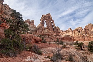
Pagan Temple by adilling The hike starts at the Elephant Hill Trailhead. There's ample parking with an additional overflow lot. There's a vault toilet at the trailhead. The trailhead is 6 miles past the Needles Visitor Center. The road turns into a well-groomed dirt road right before the Needles Campsites. The road continues past the trailhead, but it turns into a serious 4x4 road.
The rest of the hike to the arch is hiking in or along the wash in Elephant Canyon. The closer you get to the arch, the steeper the trail becomes. Eventually, you leave the canyon for good and hike along the edge. After making several turns and twists, the canyon ends at the chute area below the arch. The first view of the arch is deceiving. It appears to be just another part of the amazing scenery. The chute area is 0.5 miles up. There are a couple of paths you can take up (and back down). It is more of a rock scramble than a hike until you make it up to the ledge the arch is on. The first real views of the size and scope of the arch are from the chute area. Once you make it up to the ledge, the arch and the amazing canyon you just hiked up come into full view. The arch is 150 ft tall and consists of colorful Cedar Mesa Sandstone. It blew me away the first time I saw it back in the 1980's. It was no less spectacular seeing it 40 years later. Looking down at the canyon is also amazing. The scenery of the Needles District is truly unique and iconic Utah. The hike back is all down until you make it to the Chesler Park Trail junction. There is a connector trail off the Druid Arch Trail 2 miles north of the arch that climbs up to Chesler Park which is equally amazing. There are official campsites along the hike that require permits and must be reserved. A day hike doesn't require any additional permits. If you can only do one hike in the Needles District, I would recommend this one. If you have multiple days to spend, Chesler Park, The Joint Trail, Squaw Canyon and Big Spring Canyon are all nearby. Check out the Triplogs. Leave No Trace and +Add a Triplog after your hike to support this local community. | |||||||||||||||||||||||||||||||||||||||||||||||||||||||||||||||||||||||||||||