Route Editor

| Guide | ♦ | 4 Triplogs | 0 Topics |
details | drive | no permit | forecast | route |
stats |
photos | triplogs | topics | location |
| 47 | 4 | 0 |
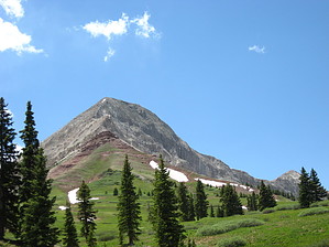
Harder than it seems by Jim The hike begins easy enough. From Coal Bank Pass, go north on US 550 a couple of hundred feet or so and find the dirt road to the west. Hike this, or drive this, to the parking area and sign for the Pass Trail. This trail is a nicely built Forest Service trail through the spruce forest to treeline where it meets a cross trail. You'll gain a fair amount of elevation and most of your miles in this section.
Engineer is not as easy as you might think, but a lot of people summit it. I would not do this casually in monsoon season, as even though not terribly high for the state, it is a high area and I would not want to be on this rock when wet. Never mind the lightning. Really, given the choice between a late start on a 14er walk up or this during the peak of monsoon season, I would take the walk up. Check out the Official Route and Triplogs. Leave No Trace and +Add a Triplog after your hike & climb trip to support this local community. | ||||||||||||||||||||||||||||||||||||||||||||||||||||||||||||||||||||||||||||||||||||||||||||||||||||||||||||