Route Editor

| Guide | ♦ | 3 Triplogs | 0 Topics |
details | drive | permit | forecast | map |
stats |
photos | triplogs | topics | location |
| 106 | 3 | 0 |
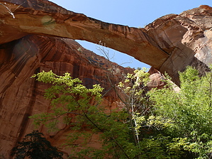
Yeah You're Gonna Get Our Feet Wet by Trishness  We started our hike at the Escalante Trailhead and the trail immediately splits...the trail to the left (west) goes downstream toward Maverick Bridge and Phipps Arch...we took the right fork (east) and went upstream toward Escalante and the Escalante Natural Bridge. There is an immediate river crossing which is only shin deep but emitted a squeal from me because it is COLD. This turned out to be a big plus on the way back! After the first river crossing you are hiking along the river but in an open bench area through sand which is now sticking to your wet feet. We did a few Big Bopper stomps, hit our feet against some rocks and with our trekking poles to get some of the sand out. I wore Keen Newport H2Os and they were fine on this although a lot of sand seemed to get underneath my toes and in the front of the shoes. NO FEAR! There are 4 more river crossings before you reach the bridge so just when you thought your feet were weighing 50 more pounds from the collection of sand you can stand in the river and rinse them only to hike up the other side into MORE fine sand. At the fifth river crossing STOP and look to your left. There is the bridge! There is no sign and we almost walked passed it. You have to scramble up a bit of eroded beach to get there as it is tucked away and looks like alcove but it is WAY AWESOME. After visiting here you can continue upstream as long as you want as we did although the trail disappears after you reach a very shady beach area called Sand Bench Creek. There is also an un-named arch back in the area which I think I'll call "Sandy Arch".....if you get back there just call it waht you want! You must walk upriver IN the river to continue from here. We turned around here and started back which is where the cold river felt great because by now the sand collecting in my shoes was HOT. I stopped at every river crossing to cool my feet and rinse the sand out of them~~~~now this cool river feels GREAT on my feet.
Check out the Triplogs. Leave No Trace and +Add a Triplog after your hike to support this local community. | |||||||||||||||||||||||||||||||||||||||||||||||||||||||||||||||||||||||||||||||||||