Route Editor

| Guide | ♦ | 26 Triplogs | 2 Topics |
details | drive | permit | forecast | map |
stats |
photos | triplogs | topics | location |
| 523 | 26 | 2 |
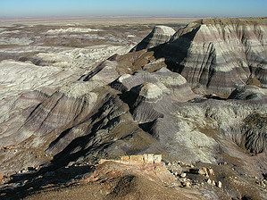
Beyond anything Grand by HAZ_Hikebot   The Painted Desert is a large swath of Arizona sweeping from Tuba City to Holbrook. Due to the virtually trail-less land, it's unlikely many would hike the same route or even want to. Please use this page to post various photos, triplogs, and routes. The Painted Desert is a large swath of Arizona sweeping from Tuba City to Holbrook. Due to the virtually trail-less land, it's unlikely many would hike the same route or even want to. Please use this page to post various photos, triplogs, and routes.Painted Desert is the name for a broad area of colorful badlands located in Northern Arizona in the United States. The desert stretches from the Grand Canyon National Park into the Petrified Forest National Park and runs roughly astride and just north of the Little Colorado and the Puerco Rivers. The area within the Petrified Forest National Wilderness is also known as the Painted Desert Wilderness. Much of the Painted Desert region is located within the Navajo Nation. The region is also home to some county parks such as the Little Painted Desert County Park found just north of Winslow. The Navajo and the Hopi people have lived in the region for at least one thousand years. However, the modern name for the desert comes from the Spaniards, who named it "el Desierto Pintado" due to its brightly colored landscape.
In the southern portions of the desert, Triassic Era coniferous forest remains fossilized over millions of years. Wind, water, and soil erosion continue to change the landscape's face by shifting sediment and exposing layers of the Chinle Formation. An assortment of fossilized prehistoric plants and animals is found in the region and dinosaur tracks and the evidence of early human habitation. Much of the region is accessible only by foot or unpaved road, though significant highways and paved roads cut across the area. Depending on use, location, and stay duration, travelers might be required to purchase permits from the appropriate authorities. The towns of Cameron and Tuba City, both within the Navajo Nation, are two major settlements. One interesting side note about Tuba City and Cameron is that parking lots and yards are often covered by bright red dust that is blown in from the surrounding lands by dust storms. Currently, coal and petroleum mining operations are active in the region, and red clay is retrieved from the desert by locals. This clay is then used to produce handmade pottery to be sold at roadside stands and souvenir shops. Source Wikipedia Check out the Triplogs. Leave No Trace and +Add a Triplog after your hike to support this local community. | |||||||||||||||||||||||||||||||||||||||||||||||||||||||||||||||||