Route Editor

| Guide | ♦ | 18 Triplogs | 2 Topics |
details | drive | no permit | forecast | 🔥 route |
stats |
photos | triplogs | topics | location |
| 236 | 18 | 2 |
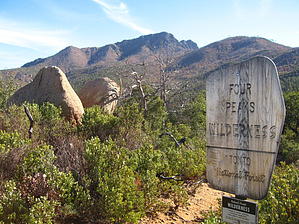
A feather in your cap by AZLOT69   Overview OverviewCounterclockwise hike on the Four Peaks Trail #130, Pigeon Trail #134, and FS 648. Hike Begin on the Four Peaks Trail #130, which is signed to the left(east). Quickly you enter into the Four Peaks Wilderness. Lovely views of Roosevelt Lake distract you from the Forest Fire damage all around you from several years ago. Trees are still falling, and in some areas, so many are down it appears like an old timber camp. New growth is evident, and the Manzanita is thriving. The trail is easy to follow and well used. At 1.09 miles, you will note a nice camp spot on the left overlooking Roosevelt Lake. The next intersection you come to is marked Amethyst Trail #253. Continue on the Four Peaks Trail # 130. At 1.23 miles, the trail descends and narrows. You will notice a ridge of pines ahead of you and then a switchback. The trail descends sharply now, and your next signed intersection is at 1.39 miles. Marked Pigeon Trail #134, turn left.
Check out the Official Route and Triplogs. Leave No Trace and +Add a Triplog after your hike to support this local community. | |||||||||||||||||||||||||||||||||||||||||||||||||||||||||||||||||||||||||||||||||||||||||||||||||||||||||||||||||||||||||||||||||||||||||||||||||||||||||||||||||||||||||||||||||||||||||||||||||||||||||||||||||||||