Route Editor

| Guide | ♦ | 7 Triplogs | 0 Topics |
details | drive | no permit | forecast | 🔥 route |
stats |
photos | triplogs | topics | location |
| 98 | 7 | 0 |
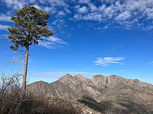
Five-Star Views of Four Peaks by John10s   Overview OverviewAt 6,612', the summit of Buckhorn Mountain is the fifth-highest point in the Four Peaks Wilderness, with only the four namesake peaks standing taller. Situated less than three and a half miles southeast of Four Peaks, Buckhorn offers top-notch views of a signature landmark of the Phoenix area. It's accessible with a round-trip hike of ~10.5 miles from Mills Ridge Trailhead, with ~8.5 miles on the well-maintained Arizona Trail and ~2 miles of moderate off-trail hiking along a ridge east/northeast of the summit. Hike Starting from Mills Ridge Trailhead, Four Peaks Trail #130 begins a steady climb to the west/southwest. The on-trail portion of the hike follows part of the Four Peaks (#20) segment of the Arizona Trail, so the path is well-maintained and easy to follow. But the workout begins immediately, with a gain of ~800' over the first 1.2 miles before the trail turns south to descend to Buckhorn Crossing ~1.6 miles in. Keep an eye out for pottery on the ground, as Four Peaks Trail passes directly through the deteriorated remains of several ancient native sites.
Around four miles in, the trail swings back to the north, winding around several drainages on the eastern side of Buckhorn Mountain. There are multiple options to approach the peak (check out the triplogs for alternate routes), but the exit point for the posted official route is a fairly nondescript point at the base of a ridge ~4.3 miles in, nearly due east of the peak. As you approach the ridge, choose a suitable spot to turn west and begin the off-trail portion of the hike. From this point to the peak, you'll cover one mile and gain a little over 1,000' of elevation. The grade is steep but consistent, with mostly stable tread. Though you'll be hiking through brush most of the way, it's not too dense in most places, and the areas of thicker brush are brief. About a half mile off the trail, the ridgeline curves slightly to the southwest, with Buckhorn's summit in sight most of the way. Here, with views finally opening up to the west, you'll get an early preview of the Four Peaks views you'll enjoy from the top. The brush is a little thicker after the curve, but staying slightly toward the north side of the ridge will allow you to avoid the worst of it. The steepness increases over the last few hundred yards before you arrive at the summit, with a tree sitting directly at the high point and a summit cairn built at the base. The peak sits on the Maricopa-Gila county border, and there's a barbed wire fence in varying states of disrepair running along Buckhorn Ridge. The summit tree and other foliage make it difficult to get a 360° view from any single point, so it's worth spending some time walking along the ridge to pick up the best views in each direction. Slightly northwest of the peak, you’ll find the most stunning, unobstructed views of Four Peaks, with a single, tall pine tree in the foreground. Looking southwest, you'll have a unique perspective of the Superstition Ridgeline, a glimpse of the Salt River, and an impressive view overlooking Hell's Hip Pocket. Off the eastern side of Buckhorn, you'll have a higher vantage point of the landmarks that were visible on the way up, including the pointed summit of Camelback Peak ~1.2 miles to the northeast, Roosevelt Lake, and the Sierra Anchas beyond. When you're ready to return, you can descend via the same ridge to connect with Four Peaks Trail and retrace your route back to the trailhead. As mentioned above, triplogs describe alternate routes up and down Buckhorn Mountain via other ridges/drainages, so if you're looking for some variety on the way down, consider one of those other options. On the hike out, there's an opportunity to extend the day with an out-and-back hike up to Camelback Peak, which adds 3 to 3.5 miles to the return, but it's an extremely brushy off-trail approach. Check out the Official Route and Triplogs. Leave No Trace and +Add a Triplog after your hike to support this local community. | ||||||||||||||||||||||||||||||||||||||||||||||||||||||||||||||||||||||||||||||||||||||||||||||||||||||||||