Route Editor

| Guide | ♦ | 4 Triplogs | 0 Topics |
details | drive | permit | forecast | route |
stats |
photos | triplogs | topics | location |
| 68 | 4 | 0 |
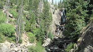
Pick between long and hard and short and easy by slegal For those that want to get in a little more exercise than just a half mile round trip, the Fish Creek Falls trail does continue past Fish Creek Falls. At the bottom of the downhill you reach a bridge with a great view of waterfall. After crossing the bridge the trail heads uphill past several switchbacks until continuing up the canyon above Fish Creek. The trail is fairly steep and unrelenting for quite a distance. Fortunately, there is plenty of shade throughout the hike as tree cover is fairly thick.
If you've feeling energetic after reaching the upper falls, another 2.5 miles up the trail will get you to Long Lake. The hiking book that I have for Steamboat Springs area hikes says that moose sightings in the Long Lake area are not uncommon. Just be aware, that the sign at the trailhead appears to underestimate the distance to Long Lake by about a half mile one way. So it is about an 11 mile round trip to the lake and about a 2,200 foot elevation gain. Check out the Official Route and Triplogs. Note This is a moderately difficult hike. Leave No Trace and +Add a Triplog after your hike to support this local community. | |||||||||||||||||||||||||||||||||||||||||||||||||||||||||||||||||||||||||||||||