Close to town - good when you have little time and want a workout. A short, steep jaunt to the top of Frenchman Mountain. From the top, you enjoy truly professional-quality views of the Las Vegas valley.
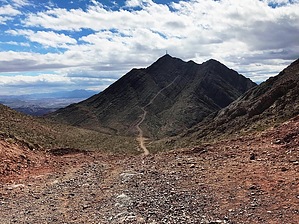
The road you hike on was put in to place radio tower and airway beacon equipment on the dual peaks of Frenchman Mountain. It was also used to access numerous old mining efforts. Clearly, this road was put in long before the concept of soil erosion was a thought. The key concept here is "straight up the gut." Switchbacks are a mere afterthought, used only where it appears there was absolutely no other choice.
The hike begins up a steep road and levels out for a short time with some decent views back to where you came from. You rapidly begin ascending again on a steeper grade leading to a few switchbacks at the top of a saddle. Views are limited here, although it does provide off-trail access to minor (but very steep and rocky) peaks on each side of the saddle. The hike now descends steeply, providing a warm-up for your hike back, but also losing a lot of the elevation you just worked so hard to gain. Views from the bottom are better than expected out toward the Vegas valley. The last push is up the steepest section of all - from the bottom, the angle almost looks impossible. A few switchbacks toward the top and the road levels out just beside the more northern peak. Turn left when the road splits for the northern peak, or continue straight to reach the southern peak. The northern peak is the highest point by a bit, but the highest point itself is technically within the fenced area near the radio towers. Either way, enjoy the stunning views of the Vegas valley and over to Lake Mead.
Warning: There is no shade and no water on this hike. The path is very steep, eroded, and covered with loose rocks. Be smart and be careful.
WARNING! Hiking and outdoor related sports can be dangerous. Be responsible and prepare for the trip. Study the area you are entering and plan accordingly. Dress for the current and unexpected weather changes. Take plenty of water. Never go alone. Make an itinerary with your plan(s), route(s), destination(s) and expected return time. Give your itinerary to trusted family and/or friends.
To hike From Las Vegas, take I-15 to the Lake Mead Blvd exit.
Travel east on Lake Mead Blvd for approximately 8 miles. The trailhead is on the right side of the road at the metal gate closing off an unpaved road - this road is the trail.
page created by HAZ_Hikebot on Sep 07 2013 11:14 am
 Route Editor