username
X
password
register
for free!
help
 This is likely a great time to hike this trail!  Check out "Preferred" months below, keep in mind this is an estimate.
  

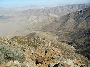
Garnet Peak Trail, CA

Guide 3 Triplogs  0 Topics
  0 of 5  
Fav
Wish
0
details
drive
permit
forecast
route  
stats
photos
triplogs
topics
location
4 3 0
Statistics
tap row or icons for details
Difficulty 1.5 of 5
Distance Round Trip 2.25 miles
Trailhead Elevation 5,386 feet
Elevation Gain 498 feet
Accumulated Gain 498 feet
Kokopelli Seeds 4.74
unreported if dogs are allowed
editedit > ops > dogs to adjust
feature photo
Photos Viewed All MineFollowing
4  2012-10-07 robxxx
Author
author avatar Guides 16,843
Routes 17,472
Photos 24
Trips 1 map ( 6 miles )
Age 28 Male Gender
Location HAZ, TrailDEX
Associated Areas
list map done
San Diego Region
Historical Weather
Trailhead Forecast
Radar Map
Expand Map
Preferred May, Oct, Jun, Sep
Sun  5:23am - 6:06pm
Official Route
 
1 Alternative


remove free decal offer

 Likely In-Season!
Garnet Peak is located in the Laguna Mountains area of the Descanso District and offers stunning viewpoints at 6000 elevation and an intense workout with a dramatic climbs at the peak. If starting at the Penny Pines Trailhead and hiking through the Pacific Crest Trail (PCT) the Garnet Peak offers a 1.2 mile out-and-back uphill incline as a stand alone trail off of the PCT. If parking at the Garnet Peak trailhead, the 2.2 round trip trail still packs quite a punch with its aggressive incline, and the views are well worth the trip. It should be noted however, that this trail is extremely rocky, with loose gravel and potential hazards.

2019-04-02 HAZ_Hikebot


    Check out the Official Route and Triplogs.
    Leave No Trace and +Add a Triplog after your hike to support this local community.
    WARNING! Hiking and outdoor related sports can be dangerous. Be responsible and prepare for the trip. Study the area you are entering and plan accordingly. Dress for the current and unexpected weather changes. Take plenty of water. Never go alone. Make an itinerary with your plan(s), route(s), destination(s) and expected return time. Give your itinerary to trusted family and/or friends.

     Permit $$
    no fees or permits reported

    if incorrect tell us about it

    Cleveland Forest
    An Adventure Pass is needed when parking at any TH located in the Cleveland NF.

    More information available here


     Directions
    or
     Road


    To hike
    I-8 east to Sunrise Highway - each side: Garnet Peak Rd. (27.8 Mile Marker) and Penny Pines (27.8 Mile Marker) on Sunrise Highway.
    page created by HAZ_Hikebot on Mar 09 2010 11:54 pm
     90+° 8am - 6pm kills
    helpcorrectionissue

    end of page marker