|
tap row or icons for details
|
| Difficulty |
|
2 of 5 |
| Route Finding |
|
2 of 5 |
| Distance Multi-Loop |
|
13 miles |
| Trailhead Elevation |
|
1,500 feet |
| Elevation Gain |
|
400 feet |
| Accumulated Gain |
|
400 feet |
| Avg Time Round Trip |
|
3 hours |
| Kokopelli Seeds |
|
15 |
| | Backpack No | |
| | |
|
|
2 |
2026-04-12 | gummo |
|
|
6 |
2026-03-31 | gummo |
|
|
6 |
2026-03-28 | gummo |
|
|
5 |
2026-03-24 | gummo |
|
|
3 |
2026-03-23 | gummo |
|
|
1 |
2026-03-13 | gummo |
|
|
1 |
2026-03-01 | gummo |
|
|
2 |
2026-02-15 | gummo |
| | Page 1, 2, 3, 4, 5 ... 26 |
| |
|
|
|
list |
map |
done |
Phoenix Region |
| | |
|
| |
|
|
Historical Weather |
| Trailhead Forecast | | |
|
 |
|
|
| Preferred Nov, Dec, Jan, Feb → 8 AM |
| |
|
|
| | |
| |
Named Locations Coordinate Links
| |
|
|
Hawes Trail System
|
7.79 mi
1,267 ft |
 |
|
Hawes Trail System
|
10.23 mi
1,450 ft |
|
|
Hawes Trail System
|
7.79 mi
1,003 ft |
|
| Hawes Trail System
|
8.47 mi
1,322 ft |
|
|
| Hawes Trail System
|
8.97 mi
1,618 ft |
|
|
| Hawes Trail System
|
10.12 mi
1,235 ft |
|
|
| Hawes Trail System
|
9.18 mi
1,384 ft |
|
|
|
Hawes Trail System
|
4.29 mi
851 ft |
|
|
Hawes Trail System
|
11.51 mi
2,644 ft |
|
|
Hawes Trail System
|
5.78 mi
715 ft |
|
|
Hawes Trail System
|
2.52 mi
278 ft |
|
|
Hawes Trail System
|
8.07 mi
1,288 ft |
|
|
Hawes Trail System
|
6.2 mi
815 ft |
|
| Hawes Trail System
|
8.84 mi
1,446 ft |
|
|
| Hawes Trail System
|
5.41 mi
723 ft |
|
|
| Hawes Trail System
|
3.26 mi
951 ft |
|
|
| Hawes Trail System
|
6.38 mi
1,019 ft |
|
|
| Hawes Trail System
|
12.42 mi
2,114 ft |
|
|
| Hawes Trail System
|
9.41 mi
1,008 ft |
|
|
| Hawes Trail System
|
10.5 mi
1,327 ft |
|
|
| Hawes Trail System
|
11.33 mi
0 ft |
|
|
| Hawes Trail System
|
6.52 mi
991 ft |
|
|
| Hawes Trail System
|
5.23 mi
694 ft |
|
|
| Hawes Trail System
|
10.21 mi
985 ft |
|
|
|
Twisted Sister - Hawes
|
8.53 mi
1,243 ft |
|
| Saguaro Trail #50 - Hawes
|
4.17 mi
470 ft |
|
|
| Boulderdash Trail - Hawes
|
9.2 mi
1,455 ft |
|
|
|
Hawes Meander
|
8.69 mi
1,247 ft |
|
| Hawes Trail #52 - Hawes
|
9.95 mi
1,542 ft |
|
|
| Hawes Trail to Peak 2959
|
3.93 mi
1,311 ft |
|
|
| Hawes 6-mile loop
|
6.1 mi
967 ft |
|
|
| Hawes - Pig Trail?
|
0.95 mi
154 ft |
|
|
| Hawes - Access?
|
0.08 mi
0 ft |
|
|
| Hawes - Ridge or Mine??
|
1.24 mi
78 ft |
|
|
| Hawes 4
|
0.42 mi
26 ft |
|
|
| | |
| |
|
|
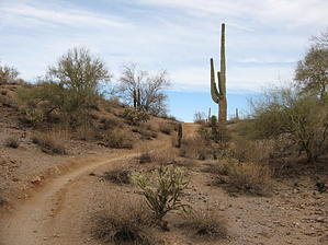
[ Hawes Mapped Area ] Looking for a quick hike or want to burn some calories on your mountain bike, close to town? Look no further than the Hawes Trail System in Northeast Mesa. While still under development, these trails already offer a great cross-country desert experience. When completed, these single track trails will join with the Usery Mountain trail system off Ellsworth and within the Usery Mountain Park System. While there is no specific destination in mind, the trails meander through the Sonoran desert, offering views of Red Mountain, Four Peaks, Fountain Hills, Granite Reef Dam, the Salt River, and the west side of Usery Mountain. Built with mountain bikes in mind but great for moderate hiking as well. The area is clean and free of trash, unlike the Granite Reef picnic area just down the road, which has been totally trashed. Not for the hiking purist, you'll be sharing the trail with bikes on some occasions. There is a map posted at the trailhead. There are several well-marked interconnecting trails so you can design your own loop for the desired distance. Made up of Hawes Trail # 52, 3.5 miles, Ridge Trail # 59, 1 3/4 miles, Saguaro Trail #50, 3 miles, Saddle Trail #51, 1.5 miles, Granite Trail # 54, the Mine trail, Twisted Sister and the Wild Horse Trail. The last three mentioned are not marked yet. They are part of the Sonoran Desert Trail System Expansion Project that will designate them as official trails, but they do exist. The map I have included is not official yet but will help you to decide on a route.
Note
Map removed as it contained an unauthorized trail on the reservation. Everything east of Power Rd seems fine and within the Tonto National Forest. |
 Route Editor