|
tap row or icons for details
|
| Difficulty |
|
0.5 of 5 |
| Route Finding |
|
1 of 5 |
| Distance Round Trip |
|
2 miles |
| Trailhead Elevation |
|
6,222 feet |
| Elevation Gain |
|
60 feet |
| Avg Time Round Trip |
|
1 hour |
| Kokopelli Seeds |
|
2.3 |
| Dogs not allowed |
| | |
|
|
15 |
2026-01-02 | ddgrunning |
|
|
12 |
2016-06-22 | cw50must |
|
|
9 |
2016-05-18 |
Canyonlands National Park |
DallinW |
|
|
|
14 |
2016-04-21 |
Island in the Sky Canyonlands |
trekkin_gecko |
|
|
|
10 |
2014-09-27 | AZWanderingBear |
|
|
2 |
2014-07-27 | leonesiegel |
|
|
8 |
2010-11-07 |
Corona Arch |
hippiepunkpirate |
|
|
|
9 |
2010-11-07 | hippiepunkpirate |
|
| |
|
|
|
list |
map |
done |
Southeast Region |
| | |
|
| |
|
|
Historical Weather |
| Trailhead Forecast | | |
|
 |
|
|
| Preferred May, Oct, Apr, Sep |
| |
|
|
| | |
| |
Named Locations Coordinate Links
| |
|
| Grandview Trail - CNP
|
2.19 mi
312 ft |
|
|
| Grandview Trail - CNP
|
2 mi
337 ft |
|
|
| | |
| |
|
|
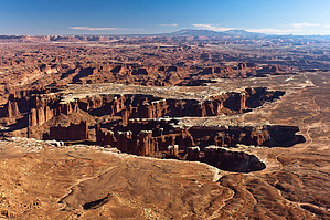
  Overview: Overview: Grand View Point is the southern most point of Canyonlands National Park's Island in the Sky. To get to the actual tip of the point requires a short and easy walk. The Grand View Overlook at the parking lot will give you a pretty impressive and satisfying view, but if you have time the short walk out to the end of the point is definitely worthwhile. Hike: The trail is mostly flat with a few small ups and downs, but no steep or substantial changes in elevation. It's kind of rough with some uneven sections of slickrock interdispersed with sandy flat spots and manmade rock steps. NPS has dropped in some large cairns to help in staying on the route. The trail follows the rim the entire way out to the tip. Expansive views are to the east and south. Directly below are the spires of Monument Basin cut into Canyonlands' signature White Rim Sandstone, with the gorge of the Colorado River just beyond. South of the Colorado, the Needles District of Canyonlands is visible far off in the valley. At the end of valley, cliffs of Wingate Sandstone can be seen on the footsteps of the Abajo Mountains and its 11,000 foot peaks. To the east, the rim of Island in the Sky leads the eye toward the La Sal Mountains and its 12,000 foot peaks that dominate the eastern skyline. The plateau country below the La Sals is filled with the maze of canyons and sandstone fins that dominate the landscape south of Moab. When you reach the tip of the point, a slickrock outcrop forms the very end, which is pretty easy to climb on top of. Views to the southwest are partially obscured by a massive hunk of rock called Junction Butte. However, impressive views to the west open up. You can explore to the west of the point to take in these views as well. Far below is another series of distinctive White Rim canyons that surround the gorge of the Green River. Dominating the western skyline are the massive Orange Cliffs, with the elongated profile of the Henry Mountains on the far horizon. Glimpses further south are the Maze District of Canyonlands. Enjoy the world class views! |
 Route Editor