Route Editor

| Guide | ♦ | 15 Triplogs | 0 Topics |
details | drive | no permit | forecast | route |
stats |
photos | triplogs | topics | location |
| 135 | 15 | 0 |
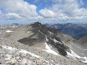
Bag a Twofer by rvcarter The proximity of Grays and Torreys to one another, about 0.9 miles as the crow flies, across a 13,707-foot saddle, makes for an excellent opportunity for fit hikers to bag a twofer. Getting to the second peak involves descending to the saddle, then climbing an additional 600 feet, which is difficult at that elevation. Our group chose not to attempt the Torreys climb because we were spent just getting to Grays, and because hikers had to cross a thawing snowfield coming down from the saddle to rejoin the main trail. No one in our group wanted to climb another 1200 feet (including the 600 feet back to Grays) retracing our steps to get down.
You're above the tree line at the trailhead. The trail to Grays is not bad, beginning with an initial short climb along the remnants of the old Stevens mine nestled at the base of McClellan Mountain to the south. This is followed by a gently rising stretch through lots of wetland willows, some water, and lots of wildflowers. The final portion, which involves most of the elevation gain, is a pretty steep and rocky climb up multiple switchbacks to the top. Near the top, expect considerable stretches of rocky trail but no scrambling. The direct approach to Torreys is much the same, but be aware that the snow field below the saddle between Grays and Torreys may survive into early August. If you have extra energy, you can bag the 13,164-foot Kelso Mountain passed on the way up. Each of the peaks will reward hikers with spectacular views of both sides of the Continental Divide. Lake Dillon and some of Frisco is clearly visible to the west. The valley that contains Fairplay, Colorado is to the south. All in all, climbing either or both peaks (in the summer) is a great day in central Colorado. Check out the Official Route and Triplogs. Leave No Trace and +Add a Triplog after your hike to support this local community. | ||||||||||||||||||||||||||||||||||||||||||||||||||||||||||||||||||||||||||||||||||||||||||||||||