Route Editor

| Guide | ♦ | 14 Triplogs | 0 Topics |
details | drive | no permit | forecast | route |
stats |
photos | triplogs | topics | location |
| 111 | 14 | 0 |
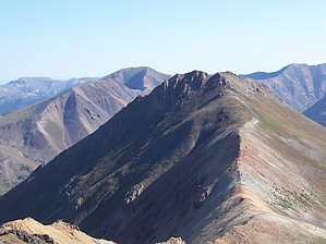
A Handie Dandy Hike by DixieFlyer This guide describes the hike to Handies Peak via the standard route on the southwest slopes using the American Basin Trail. History Handies Peak is in an area of Colorado that began to be settled in the 1870s in conjunction with mines that produced gold, silver, copper, and lead. By 1900 the Tabasco Meat Sauce Company, which was the financier for a silver mine in the area, had built a 100-ton mill to process ore from the local mines.
Hike The hike to Handies Peak on the American Basin Trail is considered to be one of the easiest 14ers to hike. However, there are no "easy" 14ers, so perhaps it is more accurate to say that this hike is one of the least difficult 14ers. This is a class 1 hike on a well-marked and easy-to-follow trail. The hike begins at around 11,600', which is a higher elevation than many 14ers. The stats on this hike assume that you begin the hike at the 4WD trailhead. If you don't have a 4WD vehicle with decent clearance, you'll want to park on the Alpine Loop at the turnoff for American Basin. This would add about 1.5 miles round-trip and 300' of elevation gain to the hike. Fees There are no fees for parking, hiking, or camping. Warning Thunderstorms are not uncommon during the summertime, so it is advisable to check weather forecasts before hiking Handies Peak. Storms typically occur after 11:00 AM or so, so it is best to begin hiking early. Check out the Official Route and Triplogs. Leave No Trace and +Add a Triplog after your hike to support this local community. | |||||||||||||||||||||||||||||||||||||||||||||||||||||||||||||||||||||||||||||||||||||