username
X
password
register
for free!
help
 

Anza-Borrego Desert State Park, CA

Guide 27 Triplogs  0 Topics
  4.5 of 5  
Fav
Wish
5
details
drive
no permit
forecast
map
stats
photos
triplogs
topics
location
950 27 0
Statistics
tap row or icons for details
Distance Round Trip 0 miles
Trailhead Elevation 768 feet
unreported if dogs are allowed
editedit > ops > dogs to adjust
feature photo
Photos Viewed All MineFollowing
15  2024-12-03
Ladder Canyon Trail
trekkin_gecko
20  2024-12-03
Ladder Canyon Trail
johnlp
8  2024-12-01 trekkin_gecko
12  2024-12-01 johnlp
19  2021-05-19 rwstorm
30  2017-03-31 gummo
22  2017-01-16 RedRoxx44
29  2016-01-16 gummo
Page 1,  2,  3,  4,  5
Author
author avatar Guides 16,843
Routes 17,472
Photos 24
Trips 1 map ( 6 miles )
Age 28 Male Gender
Location HAZ, TrailDEX
Associated Areas
list map done
San Diego Region
Historical Weather
Trailhead Forecast
Expand Map
Preferred Dec, Jan, Feb, Nov
Sun  5:22am - 6:07pm
0 Route
 
1 Alternative


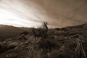
Big State, Big Park, Big Sheep
by HAZ_Hikebot

Note: This is a general entry. Specific entries within the area are certainly welcome.


Anza-Borrego Desert State Park in southern California is the largest state park in California. The park is located on the eastern side of San Diego County, with portions extending east into Imperial County and north into Riverside County. It is about a two-hour drive from San Diego, Riverside and Palm Springs. The park is named after Spanish explorer Juan Bautista de Anza and the Spanish word borrego, or Bighorn Sheep.
remove free decal offer
500 miles (804 km) of dirt roads, 12 wilderness areas and miles of hiking trails provide visitors with an opportunity to experience the wonders of the Colorado Desert. The park features washes, wildflowers, palm groves, cacti, ocotillo and sweeping vistas. Visitors may also have the chance to see greater roadrunner, golden eagles, kit foxes, mule deer and bighorn sheep as well as iguanas, chuckwallas and the red diamond rattlesnake. Listening devices for the hearing impaired are available in the visitor center.

Most visitors approach from the east via California Highways S22, S2, or 78. Visitors from San Diego via Highways 79 and 78 have the added pleasure of driving through the mountainous Cuyamaca Rancho State Park... quite a different experience from Anza-Borrego. The highways from the east climb to 2,400 feet (731 m) or so and then descend about 2,000 feet (609 m) to the valley. Where the highway breaks out of the high-country vegetation, it reveals the great bowl of the Anza-Borrego desert. The valley spreads below, and there are mountains all around. The highest are to the north... the Santa Rosa Mountains. The mountains are a wilderness, with no paved roads in or out or through. They have the only all-year-flowing watercourse in the park. They are the home of the peninsular bighorn sheep, often called the Desert Bighorn. Few park visitors ever see them; the sheep are justly wary. A patient few observers each year see and count them, to learn how this endangered species is coping with human encroachment.

There are 500 miles of off-road trails in the state park, and 110 miles of bike and hiking trails.
Source: Wikipedia

2018-07-14 HAZ_Hikebot


    Check out the Triplogs.
    Leave No Trace and +Add a Triplog after your hike to support this local community.
    WARNING! Hiking and outdoor related sports can be dangerous. Be responsible and prepare for the trip. Study the area you are entering and plan accordingly. Dress for the current and unexpected weather changes. Take plenty of water. Never go alone. Make an itinerary with your plan(s), route(s), destination(s) and expected return time. Give your itinerary to trusted family and/or friends.

     Permit $$
    no fees or permits reported

    if incorrect tell us about it


     Directions
    or
     Road


    To hike
     90+° 8am - 6pm kills
    helpcorrectionissue

    end of page marker