 Route Editor

| Guide | ♦ | 109 Triplogs | 8 Topics |
details | drive | no permit | forecast | 🔥 route |
stats |
photos | triplogs | topics | location |
| 762 | 109 | 8 |
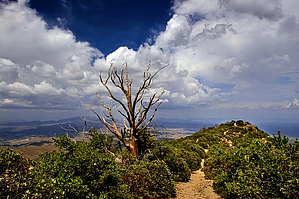
A good connection by Fritzski   The Telephone Trail is one of a group of four main trails climbing the north slope of Mt. Pinal. The elevation and north-facing slopes combine to create a surprisingly lush alpine microenvironment and some delightful hikes. I believe the stands of Aspen near the top may be the closest to the Phoenix area to be found. If you can catch this area in autumn when the leaves turn, it just doesn't get much better. The Telephone Trail is one of a group of four main trails climbing the north slope of Mt. Pinal. The elevation and north-facing slopes combine to create a surprisingly lush alpine microenvironment and some delightful hikes. I believe the stands of Aspen near the top may be the closest to the Phoenix area to be found. If you can catch this area in autumn when the leaves turn, it just doesn't get much better.Although some old mine shafts still dot the area, it is noted mainly for its logging history. Many of the trails are remnants of old logging roads, and ruins are numerous. The Telephone Trail is named after the fact that it transects the route of the power and telephone lines to the top of the mountain. Although these are now underground, there are signs that a series of old poles once held the wires.
One reason this area doesn't see more use is the lack of available resources describing the confusing network of roads and trails. As old as they obviously are, I'm not sure why these trails/old roads are not shown on the USGS topos. I've included (Official Fritzski Approved - there is no substitute!) trail and road maps that I hope will help the cause. The Telephone Trail #192 leaves the west side of the large Icehouse CCC Recreation Site/trailhead. From the sign, proceed through some manzanita scrub and across a forest road for about .2mi to the signed Icehouse Tr/198 intersection. Remain straight on #192. From here to the Doghouse Spring area, the two trails diverge, with the Telephone following the canyon's east side, offering some views of the Icehouse Tr. on the opposite side. Between the two, the Telephone offers superior scenery and a friendlier layout for the climb. The climb is a healthy one and begins up through wide tunnels of manzanita and then into the shady forest, where it begins to ease up. At about two miles, the trail once again merges with the Icehouse/198 at Doghouse Spring. This is a beautiful little spot with a water-filled hole in the middle of the trail and some old relics lying about. The two trails run together here for only about 200', where the Telephone quickly departs again up the east slope to connect over to the Sixshooter Trail. From the signpost, head up the trail, where it quickly doubles back to the north as it climbs the slope to the top of the ridge. Here the manzanita returns, and the trail again doubles back at about 3 miles to essentially climb the spine of the ridge for a way before heading along the west slope into Sixshooter Canyon. Be careful in spots to follow the most worn trail and look for small FS signs to help point the way. There are some maintenance roads for the underground power line that intersect in spots with this trail. As you approach the bottom of Sixshooter Canyon, the forest thickens from chaparral to shady pine. Just prior to the intersection with Sixshooter/197, look for some ruins on the right. These are the remains of an old sawmill. Also in the immediate area are an old spring and two old mine shafts just a few yards north on #197. The Telephone Trail officially ends here but leaves you with several options. Two worth recommendation: You can continue up the Icehouse Trail just less than one "long & steep", but a beautiful mile to the top at Ferndell Spring. Then on the way back down, loop onto the beautiful cruising Sixshooter trail to the bottom. Looking at the trail depictions, you can see that every trail offers an opportunity for several "loop" routes. Just use your imagination and enjoy!
Check out the Official Route and Triplogs. Leave No Trace and +Add a Triplog after your hike to support this local community. One-Way Notice This hike is listed as One-Way. When hiking several trails on a single "hike", log it with a generic name that describes the hike. Then link the trails traveled, check out the example. | ||||||||||||||||||||||||||||||||||||||||||||||||||||||||||||||||||||||||||||||||||||||||||||||||||||||||||||||||||||||||||||||||||||||||||||||||||||||||||||||||||||||||||||||||||||||||||||||||||||||||||||||||||||||||||


