Route Editor

| Guide | ♦ | 1 Triplog | 0 Topics |
details | drive | permit | forecast | route |
stats |
photos | triplog | topics | location |
| 31 | 1 | 0 |
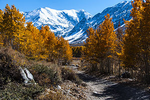
I'll make it all of the way, eventually. by slegal For the record, be forewarned if you do choose to hike this road that it is a fairly busy road with dirt bikes, ATVs and 4x4s frequently encountered and they will kick up quite a bit of dust that you will inhale during your hike. Nevertheless, you’ll see more hiking than you will driving or riding. You’ll also get a lot more exercise than everyone else.
After reaching the top of the initially climb, the road flattens out for a while as it passes right next to Laurel Creek. During fishing season you’ll likely find lots of people fishing along the creek here. There are lots of aspens along this section as well. After the flat section the road begins a long climb toward a pair of switchbacks. During this climb the road passes through a large landslide area which is a little unnerving to pass through. In one section it appears that the landslide has altered the path of the road. This section also has some pretty spectacular geology too. After passing the switchbacks, the road begins its final steep ascent to Laurel Lakes. Here is where I give my disclaimer. I have not made it all the way to upper Laurel Lake. On my last trip up I made it to about six-tenths of a mile of the end of the road, but was turned back by deep snow. I can at least say that I was above lower Laurel Lake and Was able to shoot photos. My GPS track log says that I traveled 8.7 miles. Add another 1.2 miles to upper Laurel Lake and the total trip is between 9.9 and 10 miles in length which is about on par with my hiking books. Check out the Official Route and Triplog. Leave No Trace and +Add a Triplog after your 4x4 trip to support this local community. | |||||||||||||||||||||||||||||||||||||||||||||||||||||||||||||||||||||||||||||||||||