Route Editor

| Guide | ♦ | 8 Triplogs | 0 Topics |
details | drive | permit | forecast | route |
stats |
photos | triplogs | topics | location |
| 213 | 8 | 0 |
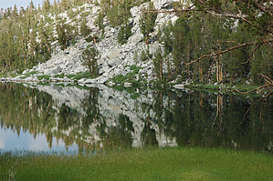
High Mineral Content by slegal The hike is a high alpine hike. The trailhead elevation is above 10,000 feet. There are no big hills to climb, but if you're not in reasonable shape you will find this hike quite tiring, just simply because of the lack of oxygen.
The trailhead is known as Mosquito Flats. It is aptly named so consider yourself forewarned and prepare with repellent. Shortly after starting out, you will pass the first of many lakes - Mack Lake. Note, with only a few exceptions, the hike will only cover lakes adjacent to the trail. There are many other lakes that you could take side trips to, so check a topo map for more information on side trips. Shortly after passing Mack Lake the trail passes Marsh Lake and then Heart Lake. I took a couple of nice photos at Heart Lake late in the afternoon under some unusually calm conditions. Shortly after Heart Lake the trail passes Box Lake. After Box Lake you will travel a distance before reaching your next lake. The largest lake on the hike is next on the agenda - Long Lake. The trail travels right beside this lake for its entire length. Next is one of the two diversions from the main trail. A worthwhile side trip is to Chickenfoot Lake. The track log will show the route to and from Chickenfoot Lake. After Chickenfoot Lake the trail heads up to Morgan Pass, the high point of the hike at just over 11,100 feet. Getting to Morgan Pass is the most strenuous part of the hike. That's not saying much though. From Morgan Pass, head back down the trail and cut off to the Gem Lakes - the second side trip. No pun intended, but the Gem Lakes are the gem of the hike. Upper Gem Lake is a pristine high Alpine Lake with a high mineral content that is clearly colored by glacial melt mineral. After Gem Lakes it's time to turn around and head back. Counting the added mileage that we had, because we parked almost a half mile away, the hike was 9.1 miles long. Enjoy. Check out the Official Route and Triplogs. Leave No Trace and +Add a Triplog after your hike to support this local community. | ||||||||||||||||||||||||||||||||||||||||||||||||||||||||||||||||||||||||||||||||||||||||||||||||||||||||||||||||||||||||||||||||||||||||||||||||||||||||||||||||||||||||||||||||||||||||||||