Route Editor

| Guide | ♦ | 12 Triplogs | 0 Topics |
details | drive | permit | forecast | 🔥 route |
stats |
photos | triplogs | topics | location |
| 195 | 12 | 0 |
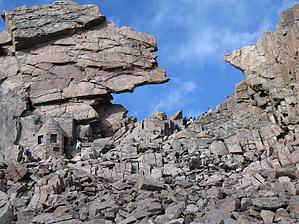
Keyhole Route by imike The day before we hit the trail this September a hiker was flipped off the trail by 70 mile per hour winds. Lightening strikes are common. Rain and sleet and snow augment the steep sections making them well beyond perilous. This mountain injures and kills hikers each year, so plan well and consider the risks before you engage this most interesting challenge.
You want to be in shape for this hike. The irregular footing and the class 3 scrambling will take it out of you. Study the map and watch the trail junctures... a surprising number of hikers make the wrong turns needlessly stretching out an already long day. The issues of high elevation hiking and inclement summer weather have to be considered and planned for; do not take this hike too lightly. That being said, trail runners have made rapid up/down traverses on this route in under 3 hours. Plan on 12 hours... if you're fit. The route up and through the class 3 section has irritating but helpful red bulls eyes... and even a few directional signs. There are areas where the sense of exposure is substantial, both perceived and real. Read some of the triplogs and make an informed decision before undertaking this great hike. Hike: Head up the East Longs Peak trail. Hike about 0.5 mile to a trail junction - stay left on the main trail. Continue through Goblins Forest. Switchback up a hill before crossing Alpine Brook on some log bridges. Leave the heavy forest shortly after the stream crossing and continue up to tree line near 11,000' (2.5 miles from the trailhead). Longs is now in view. Keep hiking southwest along Mills Moraine to the Chasm Lake trail junction at 11,550'. Turn right and traverse west and northwest across the northeast slope of Mt. Lady Washington. Hike to Granite Pass to find another trail junction. The North Longs Peak Trail heads off to the right. Stay left on the East Longs Peak Trail. Next hike the ascent, easy slope, just north of the Boulder Field. Switchback up the slope to reach the north end of the Boulder Field, 12,400'. The north and east faces of Longs come into view, as well as Storm Peak (13,326'). Follow the trail south into the Boulder Field and eventually to some established tent sites in the middle of the field. There is a restroom in this area. Your next goal is to reach the Keyhole - a notch in the rugged ridge between Longs Peak and Storm Peak. The trail finally runs out near 12,800' on the south end of the Boulder Field. Follow cairns up through the rocks as the terrain becomes more steep under the Keyhole. Scramble up into the Keyhole - This is often the destination for many hikers. The terrain beyond the Keyhole is more serious and it's dangerous in poor weather conditions. Pass through the Keyhole to the west side of the ridge. Glacier Gorge is down to the right and the next section of the route is off to the left. The remaining route to the summit is just under 1 mile, Turn left and follow painted bull's-eyes that mark the remaining route to the summit. Scramble south along ledges toward the Trough - The Trough is a large gully that ascends southeast toward the summit of Longs. About 1/3 of the way across, the route climbs up about 50' before descending 100'. This up and down adds a bit of complexity, but just keep looking for the route markers. Enter the Trough near 13,300' and turn left to begin the 600' ascent - The route is still well marked but it can take a bit of searching to find the bull's-eyes. Generally, climb (difficult hiking really) up the center of the Trough. Some easy scrambling is required in several areas. The rock is mostly stable but there are a few sections of small, loose rock. Near the top of the Trough, climb 30' of more difficult rock to reach the top at a small, flat area. You're now on the upper portion of the ridge that runs from Longs over to Pagoda Mountain (13,497'). Longs' south side, and much more scrambling, is beyond this point. Next, you cross The Narrows - an exposed ledge the descends slightly as it heads east across the south side of Longs. It is safest when conditions are dry, treacherous when wet or icy. Carefully climb around a couple of badly positioned rocks and continue on the Narrows - Descend slightly and continue to follow the route markers. After crossing the Narrows, scramble up onto more difficult rock to reach a point where the remaining route to the summit is visible - The final pitch is called the Homestretch. It looks worse than it is, although water or ice will make it much more difficult. A bit of concentration is still required in this area to keep the difficulty at Class 3. Again, follow the route markers. Climb up through a couple more sections of rock to reach the final portion of the Homestretch - This pitch is straightforward - follow the cracks up to the summit. Care must be taken to avoid a slide down the smooth rock. In total, climb about 300' up the Homestretch to reach the flat summit Check out the Official Route and Triplogs. Note This is a more difficult hike. It would be unwise to attempt this without prior experience hiking. Leave No Trace and +Add a Triplog after your hike to support this local community. | |||||||||||||||||||||||||||||||||||||||||||||||||||||||||||||||||||||||||||||||||||||||||||||||||||||||