Route Editor

| Guide | ♦ | 10 Triplogs | 0 Topics |
details | drive | permit | forecast | route |
stats |
photos | triplogs | topics | location |
| 41 | 10 | 0 |
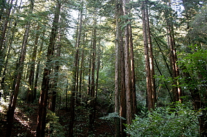
Great East Bay Hike by JimmyLyding  We started at the Redwood Gate where there is a large parking lot. It was mostly empty on January 18, 2008 when I visited for the first time, but I suspect it gets very crowded on certain days. To get started one must find the Canyon Trail which is located up-canyon to the right from the upper parking lot. It is very steep, but well-graded and short. After about 1/3 of a mile one reaches the intersection with the East Ridge Trail. The East Ridge Trail provides a good example of coastal California oak-scrub woodland. It meanders along the top of the ridge with the beautiful town of Moraga to the east and the canyon that defines Redwood Regional Park to the west. There aren't many views to the east, however, as dense brush and trees usually block the view. To the west, however, there is a great view down into the canyon. We couldn't see much of the canyon as the sun was in our eyes when we looked towards that direction, but I would wager that it is spectacular in the morning. The East Ridge Trail is basically a road, and I guess it is used for fire control. I understand a lot of the trails in the park are this way. We continued about 2 miles along this trail until it reaches a somewhat-high point that allows a gorgeous view of Mount Diablo to the east. Soon thereafter we turned left (downhill - very steep) onto the Prince Trail (another road-like trail). After a minute or two we found ourselves in almost total darkness. It took me a while to remember how to use my longer-exposure settings on my camera, and I had to figure out really quick.
As funny as it sounds the redwood forest reminded me of what we see here in Arizona w/ ponderosa pines. It didn't seem as if there were many other plants other than redwoods in the canyon bottom and on the slopes of the west side just like what one sees w/ ponderosas here. The oak-chaparral areas looked like they'd be more productive for animals because of the diversity of flora. We turned left yet again downhill on the Fern Trail until its short intersection with the Stream Trail. It is all smooth sailing from here on out as the Stream Trail winds gently downhill back to the upper parking lot. Notes: *Don't even think of fishing or swimming in the creek. They will barbecue you if you do. *Keep your dog on a leash at all times. Not only is it the law, but the area is rife with mountain lions that are quite used to taking pets. If a ranger caught your dog splashing about in the stream then you're looking at a hefty ticket. Lots of horses in the park as well. However, we saw 3 dogs and none were on a leash. *Even though we did this hike in mid-January it seemed like it was springtime. It wasn't exactly a warm day with the high in Oakland being a little less than 60. Up on the East Ridge Trail we could have gotten away with shorts and t-shirts, but down in the canyon I was glad I brought my fleece sweater. This looks to be a year round hike. I'm sure the trailhead is filled by mid-morning on hot summer days (many people in the Bay Area do not have air conditioners), and the ample parking probably regularly gets overloaded. Hiking in the dark redwood forest on a hot day sounds awfully nice. It would be like Cave Creek having the forest primeval. Anyone can imagine what a mess that would be in terms of people. *The California redwoods look very impressive, but they are second-growth from the gigantic trees that were felled right after the California gold rush (1860-ish). The trees are not transplants, but typically clones that grow right from the stump or a root. Sort of like an aspen as I understand the situation, so a more accurate term than "clones" might be "suckering" which is the term for plants growing from another's roots. I'm not 100% sure if they "sucker", but they definitely sprout right out of stumps. See the picture set. *Watch for newts! See the last picture in my photoset. We didn't see much in terms of animals other than some hawks, buzzards, and small birds. From my experience in nearby areas I'm sure there are lots of banana slugs (UC Santa Cruz alumni unite!) one can readily find crossing the trail. *There is a trailhead and visitors' center on the north side, and the trail system is quite extensive. However, the best map I can find online is pretty lame. The map they have available for free at the trailhead is one of the best freebie trail maps I have ever seen. *The truly amazing thing about this hike is that one feels a real sense of isolation during almost the entire hike despite being sandwiched between Oakland and the burgeoning suburbs along the 24 and I-680 in the East Bay. Check out the Official Route and Triplogs. Leave No Trace and +Add a Triplog after your hike to support this local community. | |||||||||||||||||||||||||||||||||||||||||||||||||||||||||||||||||||||||||||||||||||||||||