 Route Editor

| Guide | ♦ | 1 Triplog | 0 Topics |
details | drive | permit | forecast | route |
stats |
photos | triplog | topics | location |
| 10 | 1 | 0 |
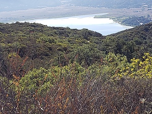
Love at First Sight by TheHikingGolfer  This hike was recommended to me by a friend of a friend who lives in the area and formerly used the trail to train search and rescue dogs. She's lived there for many years and knows the area like the back of her hand, so I was happy to give this trail a try.
Proceed through the gate (there is a sign "Love Valley Meadow Trail") onto the forest road. The road winds gently but steadily downhill for 0.8 miles where you come to a fork in the road. The meadow area is straight ahead. Take the left fork and continue winding around the meadow for about 1.2 miles until you come to a fence line and the trail basically runs out. You could continue across the meadow and return to the forest road or return along the same trail. There are no water sources along the trail and no areas to camp. It's pretty much an out-and-back trail. A good morning hike to get started with good views. Gate Policy: If a gate is closed upon arrival, leave it closed after you go through. If it is open, leave it open. Leaving a closed gate open may put cattle in danger. Closing an open gate may cut them off from water. Please be respectful, leave gates as found. The exception is signage on the gate directing you otherwise. Check out the Official Route and Triplog. Leave No Trace and +Add a Triplog after your hike to support this local community. One-Way Notice This hike is listed as One-Way. When hiking several trails on a single "hike", log it with a generic name that describes the hike. Then link the trails traveled, check out the example. | ||||||||||||||||||||||||||||||||||||||||||||||||||||||||||||||||||||||||||||||||||||||||||||


