 Route Editor

| Guide | ♦ | 1 Triplog | 0 Topics |
details | drive | no permit | forecast | route |
stats |
photos | triplog | topics | location |
| 11 | 1 | 0 |
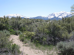
Up A Creek by AZLOT69  Hike: Described here uphill the trail starts on the north side of Lower Whites Creek. The creek has cut an impressive canyon thru this lower area exposing large granite boulders. The creek itself is heavily chocked with trees and shrubs but there is occasional open areas where you can splash your face with the very cool clear water. The trail is a steady but moderate climb for the entire distance. The trail soon climbs out of the canyon and the creek swings south. The trail proceeds west along property lines. When you come to an unmarked intersection bear left. The trail makes a beeline south to rejoin the creek. The mountains towering ahead are Mount Rose and Slide Mountain on the left. Upon reaching the creek the trail swings west again and you come to a narrow bridge crossing over to the south side of the creek. Following along the south side you come to a road. There is a fire department on the right. Cross the road as the trail continues following the creek. There are some heavily eroded spots in this area and you will come to some erosion control efforts. Twice you will have to swing out of the creek bed to the south to circumvent these erosion efforts. Shortly you will cross another bridge to the north side of the creek and continue towards the west. There will be some nice groves of Quaking Aspen now which will supply some shade. The trail comes out to a road with the trail continuing on the other side. Some large pines now come into view. Soon you are in the pines for your final crossing on a bridge to the south side of the creek. The final stretch of trail follows a property line out to Timberline Drive. Check out the Official Route and Triplog. Leave No Trace and +Add a Triplog after your hike to support this local community. One-Way Notice This hike is listed as One-Way. When hiking several trails on a single "hike", log it with a generic name that describes the hike. Then link the trails traveled, check out the example. | ||||||||||||||||||||||||||||||||||||||||||||||||||||||||||||||||||||||||||||||||||


