From the trailhead the trail heads west along the south shore of Lundy Lake, through an aspen forest. When the trail breaks free the aspen forest it begins ascending the north slope of Gilcrest Peak. You’ll immediately notice a difference between this trail and most other hiking trails in the Sierra Nevada – this one is a double track trail. I read that it was a wagon road during the mining days and was a toll road that required all mine visitors to pay a toll to pass. The toll booth is long gone.
The trail rises quite high above Lundy Lake before heading south into Lakes Canyon. If you pay attention, you will see an occasional utility pole along the trail. I counted three when I was up there. Near the mouth of the canyon there is abundant aspen and willow. Afterward, the trail heads steeply up the canyon through a mostly pine forest until it crosses an unnamed stream. Then it heads steeply through a mostly Aspen and willow lined the trail.
The trail levels out briefly with Blue Lake in the distance to the left, separated from the trail by a meadow. The trail resumes its steep ascent to the May Lundy Mine. This is a cool site. I’ve seen photos of the mine that are not all that old showing an open mine shaft (now collapsed) and a lift that carried ore cars. The lift is gone, but the ore cars can be seen below near the ruins of the stamping mill. There are still plenty of ruins present and my photoset shows some of the ruins.
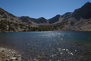
Not too far past the May Lundy Mine the trail ends at Oneida Lake. This lake is beautiful. It’s not the last lake in the canyon. The last lake is an unnamed lake further up the canyon. It is a cross country hike to get to it.
WARNING! Hiking and outdoor related sports can be dangerous. Be responsible and prepare for the trip. Study the area you are entering and plan accordingly. Dress for the current and unexpected weather changes. Take plenty of water. Never go alone. Make an itinerary with your plan(s), route(s), destination(s) and expected return time. Give your itinerary to trusted family and/or friends.
To hike From US 395 just north of Mono Lake, take Lundy Lake Road to Lundy Dam Road. Lundy Dam Road is unmarked, but there is a large sign belonging to Southern California Edison that will let you know that you’re in the right place. Lundy Dam Road dead ends at a parking area adjacent to the trailhead.
page created by HAZ_Hikebot on Oct 11 2014 10:05 pm
 Route Editor