username
X
password
register
for free!
help
 This is likely a great time to hike this trail!  Check out "Preferred" months below, keep in mind this is an estimate.
  

McConkie Ranch Petroglyph Trail, UT

Guide 4 Triplogs  0 Topics
  4 of 5  
Fav
Wish
0
details
drive
permit
forecast
route  
stats
photos
triplogs
topics
location
33 4 0
HAZ reminds you to respect the ruins. Please read the Archaeological Resources Protection Act of 1979 & Ruins Etiquette
Statistics
tap row or icons for details
Difficulty 1.5 of 5
Route Finding 1 of 5
Distance Lasso-Loop 0.75 miles
Trailhead Elevation 6,200 feet
Elevation Gain 225 feet
Accumulated Gain 280 feet
Avg Time Round Trip 1 - 2 hr
Kokopelli Seeds 2.15
 Interest Ruins
 Backpack No
unreported if dogs are allowed
editedit > ops > dogs to adjust
feature photo
Photos Viewed All MineFollowing
6  2019-09-30 AZLOT69
7  2019-05-30 Steph_and_Blake
20  2016-05-17 AZLOT69
Author
author avatar Guides 100
Routes 63
Photos 2,548
Trips 184 map ( 820 miles )
Age 76 Male Gender
Location Grand Junction, CO
Associated Areas
list map done
Dinosaurland Region
Historical Weather
Trailhead Forecast
Radar Map
Expand Map
Preferred Apr, May, Sep, Oct
Seasons   ALL
Sun  5:49am - 6:44pm
Official Route & 1 Rt
 
0 Alternative


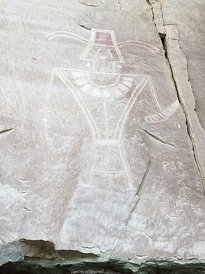
Five Star Visitor Experience
by Steph_and_Blake

 Likely In-Season!
Overview
Hundreds of Classic Vernal style petroglyphs and pictographs on a private ranch in Dry Fork Canyon.


Hike
After parking, "check in" at the "visitor center" (a wooden building on the north side of the parking lot). At the time of our visit a $5 donation was suggested. Information on the rock art has been made available on a side table across from the register.
remove free decal offer
Upon leaving the visitor center, head northeast to two dirt paths that lead up to the sandstone cliff face. We would suggest taking the path on the right and making a counter-clockwise loop. After a short ascent among boulders and trees you'll arrive at the cliff and immediately see the first of the rock art.

In our opinion, the initial images aren't all that spectacular (compared to other rock art in the area) and you might think to yourself "I'm glad I only paid 5 dollars". However, as you move to the left, the site's offerings begin to improve. Soon you'll see ornately decorated human figures, some holding what appear to be a bloody head. Most of the figures are large anthropomorphs replete with headdresses, sashes, earbobs and necklaces.

Continue along the cliff face, taking care not to touch the sandstone wall, to view more and more images. Eventually you'll come to the signed end of the rock art and need to retrace your steps until arriving at a right-hand turn leading down to the starting point.

Water Sources
The ranch owners have kindly made available cold, bottled water for a small price - located in the fridge in the "visitor center".

2019-06-04 Steph_and_Blake


    Check out the Official Route and Triplogs.
    Leave No Trace and +Add a Triplog after your hike to support this local community.
    WARNING! Hiking and outdoor related sports can be dangerous. Be responsible and prepare for the trip. Study the area you are entering and plan accordingly. Dress for the current and unexpected weather changes. Take plenty of water. Never go alone. Make an itinerary with your plan(s), route(s), destination(s) and expected return time. Give your itinerary to trusted family and/or friends.

     Permit $$
    information is in description


     Directions
    or
     Road
    Paved - Car Okay

    To hike
    From Vernal drive north on Highway 121 for about 3.5 miles. Turn right on 3500W and drive for about 6.5 miles. Turn right at the sign for McConkie Ranch.
    page created by HAZ_Hikebot on Jun 04 2019 8:27 am
     90+° 8am - 6pm kills
    helpcorrectionissue

    end of page marker