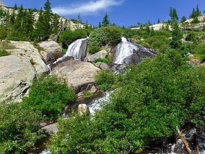
The trail is located south of Breckenridge on the north side of Quandary Peak, elevation 14,265 feet. From the trailhead you will be hiking on an old mining road through the McCullough Gulch drainage. Although private property exists along this trail, hikers and mountain bikers are allowed access and are asked to stay on the trail. Eventually you turn onto a trail that leads you to a viewpoint of White Falls. You can continue up the trail to a beautiful alpine lake with a magnificent view of the entire McCullough Gulch drainage.
When hiking several trails on a single "hike", log it with a generic name that describes the hike. Then link the trails traveled, check out the example.
WARNING! Hiking and outdoor related sports can be dangerous. Be responsible and prepare for the trip. Study the area you are entering and plan accordingly. Dress for the current and unexpected weather changes. Take plenty of water. Never go alone. Make an itinerary with your plan(s), route(s), destination(s) and expected return time. Give your itinerary to trusted family and/or friends.
Permit $$
no fees or permits reported
if incorrect tell us about it
Directions
Road
To hike From I-70 take Exit 203, Frisco/Breckenridge, and travel south on Hwy 9 toward Breckenridge. Continue through Breckenridge and travel approximately 7.4 miles past the last traffic light in Breckenridge at Boreas Pass Road. You will pass through the town of Blue River on the way toward Blue Lakes Road (FDR 850) where you will turn right. Turn right onto McCullough Gulch Road (FDR 851) approximately 0.1 miles from HWY 9. At the fork in the road in approximately 1.7 miles, stay to the left. Follow McCullough Gulch Road to the gate where you will find the parking area. Please do not block the gate.
page created by HAZ_Hikebot on Mar 10 2010 12:09 am
 Route Editor


