McLeod Lake Trail, CA • Hike
username
X
password
register
for free!
help
   🔥

McLeod Lake Trail, CA

Guide 3 Triplogs  0 Topics
  3 of 5 
Fav
Wish
0
details
drive
permit
forecast
🔥
route  
stats
photos
triplogs
topics
location
42 3 0
Statistics
tap icons for details
Difficulty 2 of 5
Route Finding 1 of 5
Distance Lasso-Loop 1.8 miles
Trailhead Elevation 9,011 feet
Elevation Gain 408 feet
Accumulated Gain 408 feet
Avg Time Round Trip 2 hours
Kokopelli Seeds 3.84
 Backpack Yes
unreported if dogs are allowed
editedit > ops > dogs to adjust
feature photo
Photos Viewed All MineFollowing
Inaugural Calculation on Button Tap!
13  2016-07-20
Horseshoe Lake & McLead Lake
John9L
6  2016-07-20 chumley
11  2013-07-20 slegal
8  2013-07-16 slegal
4  2009-09-07 slegal
Author
author avatar Guides 74
Routes 101
Photos 2,962
Trips 57 map ( 363 miles )
Age 60 Male Gender
Location Thousand Oaks, CA
Associated Areas
list map done
Sierra Nevada Region
Historical Weather
Trailhead Forecast
Radar Map
Expand Map
Preferred Aug, Jul, Sep, Jun
Seasons   Late Spring to Early Autumn
Sun  6:01am - 6:07pm
Official Route
 
1 Alternative
 
 Water
Historic Fire Perimeteracres
🔥 2020 Creek Fire834


McLeod Lake is one of many lakes located in the Mammoth Lakes basin. It is the western most of the basin lakes. Beyond McLeod Lake to the west is Mammoth Pass, and almost 2,000 feet below Mammoth Pass is Devil's Postpile National Monument. This is another one of those hikes that I consider when I want to hike, but I'm either short on energy or time.


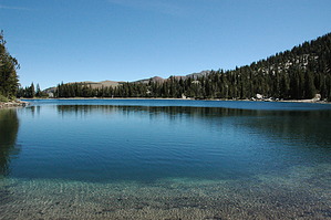
The trailhead to McLeod Lake is at the Horseshoe Lake parking lot. Like the Horseshoe Lake trail, the McLeod Lake trail passes an area of carbon dioxide out gassing. The entire forest at the trailhead died in the 1990's. After a series of earthquakes caused by movement of magna below the surface, carbon dioxide came to the surface and killed all of the trees. You might ask, don't trees use carbon dioxide to photo synthesize? Yes, but the trees died at their roots. It's a stark image, but smaller trees are coming in. The question is, will the new trees survive once their roots grow deeper?

It doesn't take long for the trail to find its way into living trees. It's a pretty trail from then on, all the way to McLeod Lake. The trail is a long gradual uphill all the way to the lake.


Although there is no actual maintained trail all of the way around McLeod Lake, it isn't difficult to find your way all the way around the lake. Lots of people make their way all of the way around the lake, so there are well worn trails. In places you'll have to do some rock hopping, but nothing too difficult. I highly recommend making the loop all the way around the lake.

Check out the Official Route and Triplogs.

Leave No Trace and +Add a Triplog after your hike to support this local community.

2011-03-13 slegal
    WARNING! Hiking and outdoor related sports can be dangerous. Be responsible and prepare for the trip. Study the area you are entering and plan accordingly. Dress for the current and unexpected weather changes. Take plenty of water. Never go alone. Make an itinerary with your plan(s), route(s), destination(s) and expected return time. Give your itinerary to trusted family and/or friends.

     Permit $$
    None


     Directions
    or
    or
     Road
    Paved - Car Okay

    To hike
    From the town of Mammoth Lakes take Lake Mary Road all the way to the end of the road. Lake Mary Road dead ends at the Horseshoe Lake parking area. The trailhead to McLeod Lake is located at the southwest end of the parking lot.
    page created by slegal on Mar 13 2011 7:24 pm
    helpcorrectionissue

    end of page marker