 Route Editor

| Guide | ♦ | 2 Triplogs | 0 Topics |
details | drive | no permit | forecast | map |
stats |
photos | triplogs | topics | location |
| 23 | 2 | 0 |
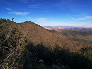
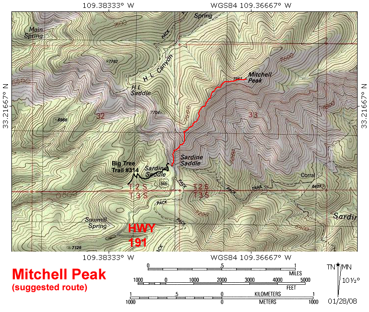
A lonely peak that no one will bag by PrestonSands   Out in extreme eastern Arizona along the winding Coronado Trail lies 7951 foot Mitchell Peak. Its rocky, rolling summit is the highest point between the town of Clifton and Rose Peak to the north. As can be expected, views from the top are outstanding. Out in extreme eastern Arizona along the winding Coronado Trail lies 7951 foot Mitchell Peak. Its rocky, rolling summit is the highest point between the town of Clifton and Rose Peak to the north. As can be expected, views from the top are outstanding.This off-trail hike requires a fair amount of bushwhacking on steep, rough terrain, so expect slow progress. The route shown on the included topo map is the route I took; however, you could start a little way north at H.L. Saddle and follow the ridgeline from there to the peak for a 2.6-mile round-trip hike.
Starting at the Sardine Saddle Picnic Area along Highway 191 (the "Coronado Trail"), walk north to the mountainside where the H.L. Canyon Trail #11 begins. Head straight up the ridge into the brush, and try to stay on the southwestern slope. Early on, you will cross an unmarked trail that connects with the H.L. Canyon Trail at H.L. Saddle. This connector trail appears to follow the grade of an old wagon road. A little later, you will cross a barbed-wire fence. A fire burned away much of the brush on this section of the ridge, sometime in the not-too-distant past, making for a slightly easier ascent. After about a 600-foot climb, you will be on Mitchell Peak's ridgeline. Far below, the Coronado Trail twists away into infinity. Follow the ridgeline to the northeast. Now the route is in a pine forest, with occasional breakouts of large juniper trees and chaparral. The ridgeline route negotiates several rocky knolls on its way to the peak. Use your best judgment for getting around these rocky outcroppings, but try to avoid the precipitous southern exposure. After hiking about a mile from the Coronado Trail, you will arrive at the summit. Just like on the ridgeline, there are almost limitless views in all directions. Hundreds of canyons that feed Eagle Creek and the San Francisco River wind through the rugged terrain thousands of feet below you. When you have seen enough of eastern Arizona, return the way you came. Just avoid that southern exposure. It's nasty!
Check out the Triplogs. Leave No Trace and +Add a Triplog after your hike to support this local community. | ||||||||||||||||||||||||||||||||||||||||||||||||||||||||||||||||||||||||||||||||||||||


