Route Editor

| Guide | ♦ | 2 Triplogs | 0 Topics |
details | drive | permit | forecast | map |
stats |
photos | triplogs | topics | location |
| 66 | 2 | 0 |
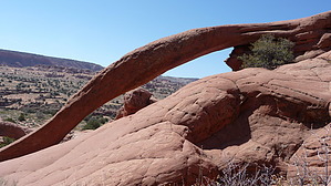
Sandy Slog to Snakey Arch by ToadOfTheRocks  From the trailhead go about a 1/5 of a mile to a drop-off, hop or walk over the fence to the right and find a cairned route that descends a small bench then south down a crack that contours down to the bottom. It's a little tricky with loose rock, so take your time. Once on the bottom find a cairned route through the slickrock and make your way down to the flatter, sandier area near Buckskin Gulch to the south. Stay low and about 1/4 to 1/8 of a mile from Buckskin to avoid too many ups and downs in the deep sand dunes. There is a faint cow/hiker trail that can be followed, but remember too keep going east.
Side trips possible south to Buckskin Gulch overlooks, which are about a 1/2 mile from arch. Check out the Triplogs. Leave No Trace and +Add a Triplog after your hike to support this local community. | |||||||||||||||||||||||||||||||||||||||||||||||||||||||||||||||||||||||