Route Editor

| Guide | ♦ | 8 Triplogs | 0 Topics |
details | drive | permit | forecast | map |
stats |
photos | triplogs | topics | location |
| 53 | 8 | 0 |
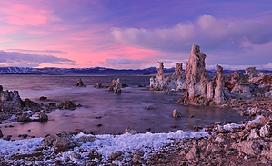
See the Tufa! by keepmoving History: According to the informational signs along the trail- the tufa structures at Mono Lake are a result of California's overuse of the lakes water supply. As water was piped from the lake to Southern California, the lake level dropped and exposed the Tufa structures. While recent conservation efforts have created a target level for the lakes water several feet higher than its current level- it will still take many years for the water level to rise.
When you arrive at the shoreline, the trail will turn east and follow a well worn path past many of the tufa structures. As you follow the main trail you will encounter various use paths that worm their way closer to some of the most popular tufa view points. If you choose to follow these paths- use caution to avoid walking on any tufa as it is extremely fragile. After reaching the end of the most prominent tufa structures along the beach, the trail will turn south and return to the main parking lot. Check out the Triplogs. Leave No Trace and +Add a Triplog after your hike to support this local community. | |||||||||||||||||||||||||||||||||||||||||||||||||||||||||||||||||||||||||||||||||||||||||||||||||