Route Editor

| Guide | ♦ | 8 Triplogs | 1 Topic |
details | drive | no permit | forecast | route |
stats |
photos | triplogs | topic | location |
| 62 | 8 | 1 |
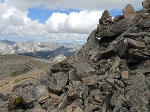
Yale is not a university by rvcarter Mount Yale, at 14,196 feet above sea level, is the 21st highest 14er in Colorado. It’s located about 10 miles west of Buena Vista, Colorado, in the Collegiate Peaks Wilderness portion of the Sawatch Range. This description is for the “standard” route (according to 14ers.com) called the Southwest Slopes route which begins at the Denny Creek Trailhead. The Denny Creek Trailhead parking lot is huge, free, and can be reached by passenger car in the summer. There are considerable camping opportunities in the area, but I didn’t see any right at the trailhead. The Collegiate Peaks CG is just back the way you came about a mile. The road has a gravel surface and is well graded (at least in the summer). It is relatively flat the entire drive in from U.S. Hwy 24. However, a winter closure gate is located just past the parking lot.
The Southwest Slopes hike to Yale has a little bit of everything that part of Colorado has to offer and is a beautiful hike in the summer. You hike along Denny Creek for about nearly a mile to the intersection of the Browns Pass Trail and Mt. Yale Trail #1451 (nice sign here). At the intersection, you turn right (northeast) and generally follow the creek passing through Delaney Gulch till you reach the tree line. At about 11,500 feet elevation, the trail turns south west for about ½ mile, then North. Here’s where the switchbacks are. The last 2,000 feet of climbing is accomplished in about a mile. Despite these daunting statistics, I felt the hike to Yale was among the easiest of the dozen or so 14ers I have done. Yale’s class 2 difficulty rating puts it slightly more difficult than 8 other 14er routes (all class 1), and in the same class 2 as Huron from the northwest and Shavano from the east, to name just a couple. However, the 14er difficulty rating is based more on the climbing difficulty than on other factors, such as accumulated elevation gain. The views along the way, once you clear the tree line, and at the top, are magnificent. The views at the top of Yale (and most other 14ers) are awesome, incredible, unbelievable…just jaw dropping. I’ve hiked a lot of places, but the 14ers of Colorado are among the best in the world. The sense of achievement one feels is….well, I’ve run out of adjectives. Suffice it to say, I highly recommend trying a 14er. If the body will let you, you won’t regret it. Just start early and keep plugging. I’m uploading a one-way track from Denny Creek TH, which is where most people will start. If I’m unable to set a new official (the current official is by Hazbot but starts at the trail’s intersection with the Brown's Pass Trail), I recommend using mine instead of the official since mine covers the entire way up. Note There is another route to Yale (not covered here), also class 2, about a mile longer and 700 feet more aeg that begins from the Avalanche Gulch Trailhead you pass on the way in from Buena Vista. The first part of the trail from Avalanche Gulch is also part of the Colorado Trail, which, if you’re backpacking the CT, may be an alternative of interest. Warning Storms accompanied by lightning, are nearly a daily occurrence in mountainous Colorado. Many hikers are struck by lightning each year. The rule of thumb is to be well off the peak before noon, but you should look at weather forecasts before starting out and watch the sky while on the trail. Gate Policy: If a gate is closed upon arrival, leave it closed after you go through. If it is open, leave it open. Leaving a closed gate open may put cattle in danger. Closing an open gate may cut them off from water. Please be respectful, leave gates as found. The exception is signage on the gate directing you otherwise. Check out the Official Route and Triplogs. Note This is a moderately difficult hike. Leave No Trace and +Add a Triplog after your hike to support this local community. | |||||||||||||||||||||||||||||||||||||||||||||||||||||||||||||||||||||||||||||||||||||||||||||||||