Route Editor

| Guide | ♦ | 17 Triplogs | 0 Topics |
details | drive | no permit | forecast | 🔥 route |
stats |
photos | triplogs | topics | location |
| 157 | 17 | 0 |
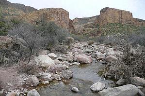
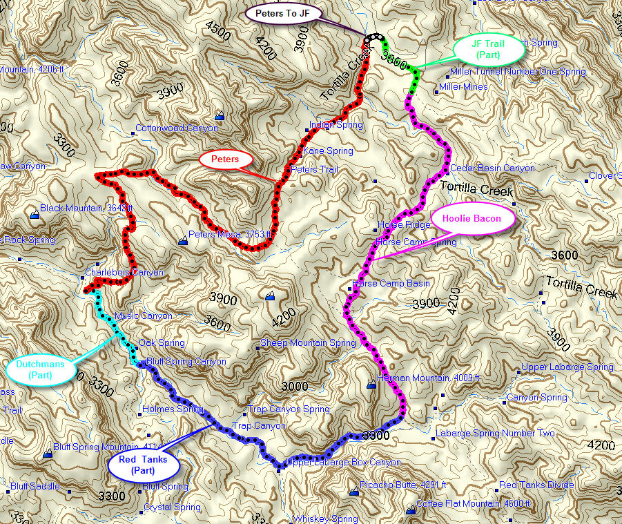
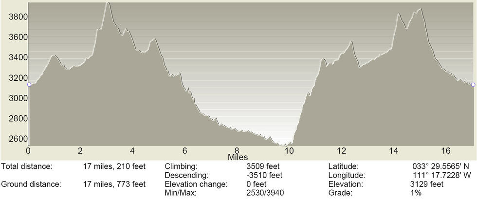
Great with water!! by gpsjoe   Overview OverviewThis loop clocked at 17.82 miles on my GPS odometer. It is long and strenuous, involving 5 trails I did in February 2008 after some significant rainfall that left plenty of water in the Superstitions' creeks and streams. I started the hike from the Peters Trailhead and went clockwise first over the road a short distance (0.18 miles) to the JF Trailhead and then making all right turns onto the JF Trail (0.77 miles), Hoolie Bacon (4.70 miles), Red Tanks (3.75 miles), Dutchman Trail (1.12 miles) and Peters Trail (7.30 miles). Access You can either park at the trailhead off route 88 and add 6.5 miles to the hike or drive to the Peters or JF trailheads (3.25 miles) over a road that requires a 4WD high clearance vehicle. I drove and parked at the Peters trailhead in my stock 2005 4Runner the night before the hike and started hiking at daybreak a few minutes before 7:00 AM. The 4Runner handled the road well, going at a snail's pace over some of the larger rocks there. I did earn some Arizona pinstripes on washed-out parts of that road. I would have no hesitation driving out there again.
Parts of this hike rate highly and parts not so high. I would rate the first mile over the road and JF trails a 1, the entire Hoolie Bacon trail a 2, the first 1.5 miles of the Red Tanks through the Upper LaBarge box is a 4 when large amounts of water are present, and a 3 when it is dry, the remaining 2.25 miles of the Red Tanks and the 1.12 miles of the Dutchman rates a 3 with lots of water and a 2 when dry. The Peters trail provides great down-canyon views as it climbs off of the Dutchmans trail and descends back to the Peters trailhead and rates a 3, in my opinion. There were many stream crossings along the way. My boots were capable of handling 2 to 3 inches of water which I did on a couple of crossings, so my socks remained dry. A little more rain, unusual as it may be, and some of the crossings would be wet. Because you pass very near Charlebois spring, the most reliable water source in the Superstitions, it would always be possible to backpack for a one-nighter camping there while doing this loop. I finished at 5:45 PM and was back on route 88 just before dark. Another excellent day hiking!!
Check out the Official Route and Triplogs. Note This is a moderately difficult hike. Leave No Trace and +Add a Triplog after your hike to support this local community. | ||||||||||||||||||||||||||||||||||||||||||||||||||||||||||||||||||||||||||||||||||||||||||||||||||||||||||||||||||||||||||||||||||||||||||||||||||||||||||||||||||||||||||||||||||||||||||||||||||||||||||||||||||