 Route Editor

| Guide | ♦ | 8 Triplogs | 1 Topic |
details | drive | no permit | forecast | route |
stats |
photos | triplogs | topic | location |
| 251 | 8 | 1 |
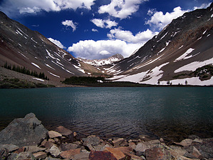
Alpine sweetness! by PrestonSands The Navajo Lake Trail #635 follows the West Dolores River to Navajo Lake, located in a high basin in the San Miguel Mountains. The trail is popular with hikers, backpackers, and those who come to bag El Diente, Mount Wilson, and Wilson Peak, all 14ers that overlook the lake. The entire area consists of spectacular glacier carved scenery. Please note that Navajo Basin is closed to campfires. Mileage and stats listed here are for a round trip hike to Navajo Lake only. A one way hike to the end of the trail at Rock Of Ages Saddle is approximately 7.3 miles with 3900 feet of accumulated elevation gain. Hike Leaving the Navajo Lake Trailhead, the Navajo Lake Trail travels alongside the West Dolores River, through pristine forest. The trail passes a junction with the Groundhog Stock Driveway Trail then continues along the river awhile, before crossing it on a footbridge. At this point the trail climbs above the riverbed into a broad sloping valley. Forest gives way to a mountain meadow with views of El Diente Peak and Mount Wilson. To the west of the trail are several small glacially derived lakes. Dolores Peak looms in the background.
Now at treeline, the Navajo Lake Trail drops to the rocky floor of Navajo Basin, arriving at Navajo Lake at 4.6 miles. Navajo Lake, which is the destination for most hikers on this trail, is a frigid sapphire jewel guarded well by high peaks all around. The awesomely rugged horn of 13,913 foot Gladstone Peak, above the eastern wall of Navajo Basin, is particularly impressive. If you are feeling adventurous, the Navajo Lake Trail continues past the lake along the rocky, treeless floor of Navajo Basin. Upon reaching the basin's upper end, the Navajo Lake Trail switchbacks up the north slope to the Rock Of Ages Saddle at 13,000 feet, where it comes to an end at a junction with the new Rock Of Ages Trail, and the currently closed Silver Pick Trail #408, at about 7.3 miles. The saddle is a popular starting point for the off trail scramble to 14,017 foot Wilson Peak. Check out the Official Route and Triplogs. Leave No Trace and +Add a Triplog after your hike to support this local community. One-Way Notice This hike is listed as One-Way. When hiking several trails on a single "hike", log it with a generic name that describes the hike. Then link the trails traveled, check out the example. | ||||||||||||||||||||||||||||||||||||||||||||||||||||||||||||||||||||||||||||||||||||||||||||||||


