Route Editor

| Guide | ♦ | 64 Triplogs | 2 Topics |
details | drive | no permit | forecast | 🔥 route |
stats |
photos | triplogs | topics | location |
| 544 | 64 | 2 |
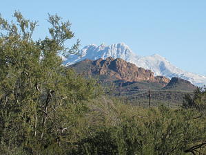
Don't fence me out by AZLOT69  Heading towards the trailhead from Rt. 60 near Exit 196 you get the first clear view of Little Four Peaks in the foreground of Four Peaks. Approaching on Rt. 88/Apache Trail heading NE, Little Four Peaks looms larger in the foreground view. Stop at the entrance to the Lost Dutchman State Park to capture the best look at their common profiles. On this classic sunny day, we are lucky to have Little Four Peaks silhouetted by fresh snow cover on Four Peaks. Leaving the State Park to concentrate on the location of Little Four Peaks (LFP). Its profile will change as you drive through the switchbacks and it disappears from view at Mile Post 204 as you move to its West. The trailhead is 1/4 mile past Mile Post 205 at a blocked dirt road on the right. Park by the road. Heading towards the trailhead from Rt. 60 near Exit 196 you get the first clear view of Little Four Peaks in the foreground of Four Peaks. Approaching on Rt. 88/Apache Trail heading NE, Little Four Peaks looms larger in the foreground view. Stop at the entrance to the Lost Dutchman State Park to capture the best look at their common profiles. On this classic sunny day, we are lucky to have Little Four Peaks silhouetted by fresh snow cover on Four Peaks. Leaving the State Park to concentrate on the location of Little Four Peaks (LFP). Its profile will change as you drive through the switchbacks and it disappears from view at Mile Post 204 as you move to its West. The trailhead is 1/4 mile past Mile Post 205 at a blocked dirt road on the right. Park by the road.The hike starts by following the dirt road 200 yds to a cairn where the road heads to the right and we head off to the left (ENE). You are in a makeshift target practice range, head toward the tan cliffs directly in front of you. There is no trail, this is a bushwhack but I did it in short pants. Warm weather would have you be cautious of snakes. Work your way up this wash towards the right. This wash is the headwaters of Willow Creek. There is no need to reach this cliff as the trail moves East towards the saddle with large boulders towards your right. At this saddle, you have a wonderful vista of First Water Creek which had flowing water on this day, Weaver's Needle, and behind you Fountain Hills.
To the south now only about one hundred yards is Little Four Peaks that sits at a similar elevation. You only lose slight elevation as you depart 2980 and head for LFP. Climb Little Four Peaks by moving SE through the saddle of the first peak. Each of the four peaks is progressively more vertical. Complete the loop by retracing back to the saddle between "2980" and LFP's first peak. Depart towards the NNE towards three saguaros that have arms. To the left of them are a couple of saguaros without arms. Go between them staying on the left side of the wash. The wash turns a slight right, stay with it moving in and out of the wash on the left side to avoid vegetation. This brings you to the dirt road traveled on at the trailhead and to your car. A great short excursion offering a nice overview of the Superstitions with moderate exertion. Check out the Official Route and Triplogs. Leave No Trace and +Add a Triplog after your hike to support this local community. | ||||||||||||||||||||||||||||||||||||||||||||||||||||||||||||||||||||||||||||||||||||||||||||||||||||||||||||||||||||||||||||||||||||||||||||||||||||||||||||||||||||||||||||||||||||||||||||||||||||||