The Water Line Trail, or Water Line Road as it is also known, is the gravel access road that climbs the east slope of the San Francisco Peaks into the Inner Basin and beyond. It is the primary access to the water pumps used to procure water from the Inner Basin for Flagstaff's water supply. At some points along the road, you come to square concrete "manholes" with access to the water line that follows the road down to town and gives the road its name. When the water is flowing, you can hear it in these manholes.
The Water Line Road has two parts; the maintained lower 2/3 and the rough upper 1/3. I have been on the lower 2/3 from Schultz Pass to the Inner Basin. It is smooth and, while not much of a hike, is an excellent mountain biking opportunity. It is about 9 miles up, and you will gain about 1700 feet to that point. The lower 2/3 is graveled and is smooth enough that a car could be driven up it, yet because the road is gated, you likely won't see motor vehicles on it. This section of road will take you to the first pump house in the Inner Basin and the trail of that name. At that point, you will encounter a faucet which is a source of water when the pumps are on. It's not filtered, but it is great for dogs and you if you have a hearty stomach. At this point, you can continue into the Inner Basin to just past the 3rd structure that you will encounter. For a full description of this, see the Inner Basin trail. This watering area is also where you may be able to continue further on the upper 1/3 of the road. Good luck if you choose to do so. I have never been more than 200 feet up on the upper portion if I was even that far. I continued up a road that logically should have been it, but I'm not sure. If it wasn't the upper part, then I have no idea where this road goes. The road isn't maintained past its meeting with the Inner Basin trail, it was badly eroded, and it had some downed trees across it. I turned back. This might be a more interesting hike, but it's not worth doing on a bike. Plus, it's more fun to go into the basin and look at the peaks. Heading down the Water Line Trail is a lot of fun, and it goes rather quickly. Be safe and try not to let your speed get away from you.
The Water Line Road is part of the boundary of the Kachina Peaks Wilderness Area. Before you get into the Inner Basin, everything past the gas line and upslope is basically the legal wilderness area, and everything downslope is legally just forest. It looks the same on either side.
One thing of interest on this trail is the vegetation. The lower part is almost pure ponderosa pine. The upper part has some lovely aspen and spruce-fir. The middle part was a decent mixed conifer stand at one time, but it has since degenerated into a thicket of young white fir in many areas. It's interesting to see the large snags of ponderosa pine, douglas fir, and even a few white firs that have died as the young white fir juveniles have outcompeted them. Unfortunately, with the dry conditions in recent times, the young trees don't always look so healthy, and I could see this area burning up in a fire at some point and hopefully converting to an aspen stand. This is something to think about when riding slowly up the road. It's best to pay attention to the road when descending.
Gate Policy: If a gate is closed upon arrival, leave it closed after you go through. If it is open, leave it open. Leaving a closed gate open may put cattle in danger. Closing an open gate may cut them off from water. Please be respectful, leave gates as found. The exception is signage on the gate directing you otherwise.
When hiking several trails on a single "hike", log it with a generic name that describes the hike. Then link the trails traveled, check out the example.
WARNING! Hiking and outdoor related sports can be dangerous. Be responsible and prepare for the trip. Study the area you are entering and plan accordingly. Dress for the current and unexpected weather changes. Take plenty of water. Never go alone. Make an itinerary with your plan(s), route(s), destination(s) and expected return time. Give your itinerary to trusted family and/or friends.
Permit $$
None
Directions
Road
FR / Dirt Road / Gravel - Car Okay
To hike From Flagstaff, proceed north on US 180 to the Schultz Pass Rd turn-off. Head east on Schultz Pass Rd to Schultz Pass, and park at the parking lot for Schultz Tank. On foot, horse, or bike, proceed about 250 feet east on the Schultz Pass Rd to the first left after the Weatherford Trail. This road is the trail. Follow as you so desire.
 Route Editor

 The Water Line Trail, or Water Line Road as it is also known, is the gravel access road that climbs the east slope of the San Francisco Peaks into the Inner Basin and beyond. It is the primary access to the water pumps used to procure water from the Inner Basin for Flagstaff's water supply. At some points along the road, you come to square concrete "manholes" with access to the water line that follows the road down to town and gives the road its name. When the water is flowing, you can hear it in these manholes.
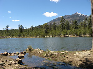


