 Route Editor

| Guide | ♦ | 2 Triplogs | 0 Topics |
details | drive | no permit | forecast | route |
stats |
photos | triplogs | topics | location |
| 36 | 2 | 0 |
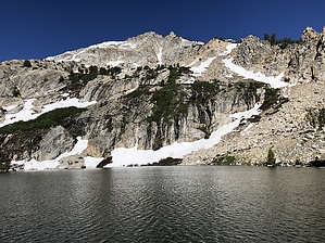
a welcome sight by LindaAnn This is a remote hike, with no water available along the trail between the trailhead and lake, and almost no shade. There is no cellular service available anywhere along the trail. Prologue This trail is the only established trail into the Ruby Mountains from the east side. It is a good access or bailout point from the middle portions of the Ruby Crest Trail.
Starting from Ruby Valley Road, you proceed approx 3/4 mile and 500' gain up a dirt road to the upper trailhead. If you have 4wd and clearance, you can drive to the trailhead sign at the upper trailhead and cut off hiking the road portion. Once past the upper trailhead and on the true trail, you will continue steadily uphill. There is a creek below you to the left, and likely cattle grazing in the area. The trail heads generally west-northwest and is in good condition. Once you top a ridge, you can see down to the next valley to the north, and the scenery is much the same, but with with more flowers during the summer. About 1.50 miles in you will begin a series of several switchbacks up a large east slope. The switchbacks are an easy grade, but get monotonous after a while. Eventually, you will head north, then curve west as you continue uphill. You can see more of the Rubies above you at this point, and the peaks look more impressive. After a mile or so of fairly easy hiking as you head west, the trail will start to steepen and the vegetation greens up. There are some switchbacks thrown in, but it's mostly a steep uphill hike at this point. Eventually, you will reach the signed junction with the Ruby Crest Trail. Turn left (south) to head up to the lake. More steep switchbacks as you head southwest towards the lake. Once you come over a small rise, the lake appears before you, and is a welcome sight. There is a small cabin at the end of the trail, apparently used to store ranching supplies. The exposed granite peaks surround the lake on three sides with dramatic effect. If you are backpacking, there are several small campsites right around the cabin, but the best sites are a little bit further to the west if you can cross over the lake's outlet. If you have the energy, follow the trail around the east side of the lake up to the small tarn above. The views down to Overland Lake from the tarn are impressive. If you are in desperate need of cell svc, climbing up the trail behind the tarn takes you to a high ridge with spotty service. Refill your water at the lake, if necessary, before retracing your steps downhill. The downhill hike goes quickly, and is fairly easy on the knees due to the good condition of the trail. Check out the Official Route and Triplogs. Leave No Trace and +Add a Triplog after your hike to support this local community. One-Way Notice This hike is listed as One-Way. When hiking several trails on a single "hike", log it with a generic name that describes the hike. Then link the trails traveled, check out the example. | |||||||||||||||||||||||||||||||||||||||||||||||||||||||||||||||||||||||||||||||||||||


