Route Editor

| Guide | ♦ | 3 Triplogs | 0 Topics |
details | drive | permit | forecast | route |
stats |
photos | triplogs | topics | location |
| 74 | 3 | 0 |
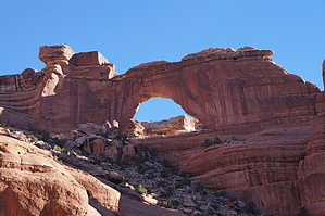
Archy falls and ruins sandstone by sneakySASQUATCH  Grand Gulch Cedar Mesa area has long been a popular area for hiking. The rugged scenery, canyons, geology, and ruins are just a few of the resources that make the area so popular with hikers. In fact, it has one of the largest concentrations of Ancestral Puebloan (Term used in the Literature in the informational ammo box at one of the sites) archeological sites. There are options available for multi-day backpacking trips in Grand Gulch or day hikes there as well. This particular loop gives you something in between with much more than just dwellings to see. It also gives you options for multi-day exploring as well. Warning In researching this trip, I read several other triplogs online warning that advanced hikers should only undertake this hike. I do believe one should be prepared and do their homework. Taking the trip in either by Owl or Fish Creek is doable, and the cairns along the trail are numerous getting into and out of the canyon. The trails are relatively easy to follow; however, there are multiple trails, not all of which go where you want to go. There was quite a difference between the actual trail I followed and what my topo had marked as the trail. Also, there are several side canyons, some with trails leading into them. Route finding skills beyond spotting cairns are necessary, especially if going down fish creek and exiting Owl Creek. There are numerous dry falls that the trail skirts by going into side canyons for small distances. Be prepared with food and water. This is a primitive area that is not as popular as some trailheads in the area where backpackers and day hikers access the same sites.
You can hike the loop either down Fish Creek and up Owl or vice versa. There is a downclimb into Fish Creek that some will find easier to lower their pack with a rope. I managed, but it was awkward and probably not doable if you carry a large, heavy pack or don't like climbing. I read it is easy to miss the point where you head up out of Fish Creek, which is part of the reason I did it in this direction, but I am happy to report that there is a metal sign in a narrow section of the canyon by a pool and hanging garden that points up the canyon. I'm sure it's possible to miss this sign, but you probably have other more pressing issues if you can miss it. :)It's a personal choice, really. Fish Creek is scenic. There are a couple of unnamed smaller arches and a couple of dwellings that you can spot with cheap binoculars. Owl creek has Neville's Arch (Which is about 2 miles from the confluence) and several dwellings, including one in an alcove just as you enter the canyon. It also has several slick rock dry falls and at least one fall that has regular water running. I found the scenery better in Owl canyon. Most of the dwellings are high up in Owl if your into that kind of stuff like me. Anyway, a cheap set of binoculars will serve you well. I spotted 6-7 during the loop. I'm sure there are quite a bit more. This hike could be done as a day hike for fit individuals but is usually done overnight or even a couple of nights. Lower Fish Creek is wider and has at least four dwellings marked on topos; the canyon is wider, and farming was done in the canyon, so the dwellings are easier to visit. Also, McCloyd Canyon is about a mile below the confluence of Owl Creek/Fish Creek and has some exploring options. Off-season permitting can be done for day use and overnight at the trail head.6/16-8/31, and 11/1-2/28, so get the getting while the getting is good! It is worth noting it was about 10 degrees cooler at the confluence than the forecast and probably hotter than forecast in the Summer. Water Sources A couple of springs in Owl Creek and several pools have to be perennial based on their current size. I was told there was water running by the ranger station in Owl and not really any mention of water in Fish. This is the other reason I went in Fish. Upon getting to the bottom of Fish by the trail sign, I was surprised that there is a large pool with hanging gardens and water dripping into said pool. There is no water for the last couple of miles in either canyon leading to the confluence. Check with the ranger station as I'm sure there are fewer water options in the summer. Camping Numerous camping spots and trees at the confluence. I found better sites just above the confluence in Owl than Fish. I found some trees in the lower confluence closer to the down canyon exploring. Enjoy! Check out the Official Route and Triplogs. Leave No Trace and +Add a Triplog after your hike to support this local community. | ||||||||||||||||||||||||||||||||||||||||||||||||||||||||||||||||||||||||||||||||||||||||