Route Editor

| Guide | ♦ | 5 Triplogs | 0 Topics |
details | drive | no permit | forecast | route |
stats |
photos | triplogs | topics | location |
| 127 | 5 | 0 |
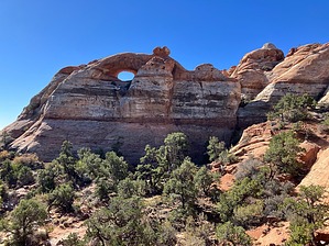
Also scenic in daylight! by John10s  Starlight Arch is one of a handful of large natural arches off of Highway 89 between Page, AZ, and Kanab, UT. This one is located on Pilot Ridge, southeast of Starlight Canyon, and can be accessed with a round-trip hike of ~11 miles starting along Paria Movie Road. Although the overall mileage and AEG are moderate, the hike is more challenging than the stats suggest, with the majority of the elevation gain concentrated in the last 1.5 miles as you ascend a steep, rocky slope up to Pilot Ridge to reach an overlook below the arch. The payoff is worth the effort, as this seldom-visited spot provides both solitude and spectacular views. Hike The scenery is impressive from the start as you begin from the Paria Movie Road parking area next to the streaked, multi-colored cliffs. From here, hike west following the dirt road as it takes a sometimes circuitous route among the banded cliffs of the Moenkopi Formation. After ~1.3 miles, take a slight right to leave the road to begin following the arroyo/wash that zig-zags northwest through a canyon. The terrain is flat and easy through this stage of the hike, but the ground may be deceptively slick and muddy; the canyon walls keep parts of the wash in shade most of the day, and the ground retains moisture long after storms pass through.
Approaching 3.5 miles into the route, the canyon starts to open up and provide better visibility of the surroundings, and the formation with Starlight Arch comes into view high up on Pilot Ridge. The wash snakes back and forth over the next half mile, and just before the four-mile mark, you'll reach another fork in the canyon. Stay right here to continue toward the color-streaked domes in that direction. Here, you'll have a clear line of sight to the destination, with Starlight Arch now fully in view. The easy part of the hike is almost over; a little farther along, a large cairn marks the approximate exit point to leave the wash and start up the steep hillside. The route provides a general guide, but there are many options available to access the ridge, so choose a route that looks best, as the hillside has a lot of loose, steep sections. Once you've gained the ridge, the path forward becomes clearer, with an unobstructed view of the steep climb ahead up Pilot Ridge. The route gradually gains elevation approaching Pilot Ridge, and though the terrain is rocky, the brush is mostly avoidable and doesn't present much of an issue. As you continue north, you may notice occasional cairns, and be sure to take the time to look back at the impressive geology of the surroundings as the views open up behind you. When you reach the base of the slope at Pilot Ridge, look for a rock formation sticking up along the ridgeline; from some angles, it looks like a small arch, but it's a notch in the rock. Here again, there's no specific route to follow, but generally aim to the left (west) of the formation and choose the path that looks the most open and stable. Over the last ~0.4 miles up to the ridge, you'll gain ~500' of elevation. Once you're on top, the route flattens out, and the views open up to the north. Veer northwest and cross the unremarkable Peak 6216, a gentle rise on the ridge. At this point, you're hiking directly toward the side of the formation with Starlight Arch, so it's not visible, though the top of this formation has a smaller, worm-shaped bonus arch that you'll see first. Closer to the formation, the route descends briefly, and you can turn left (south) or right (north) to view the arch from either side--the official route includes waypoints marking spots to view the arch from both. Each side is worth a visit, but the north side provides better views of both Starlight Arch and the surrounding area from some nearby rock outcroppings, marked with a waypoint on the posted route. To reach that spot, work your way through some trees and low brush, then it's a short scramble up to the viewpoint slightly below the arch. With some more adventurous scrambling, it may be possible to continue navigating these outcroppings around to the west side of the arch. From the scenic overlook, you'll have dramatic views looking northwest toward Kirby's Point beyond a deep, red-walled canyon below, white rock formations in the middle distance, and Mollie's Nipple behind those. There's no shortage of impressive and colorful geology in the area--to the north/northeast, you're overlooking the red rock of the Paria River basin, with lighter rock and Lower Death Valley beyond. Once you've enjoyed the arch and the scenery, you can retrace your route back down to the wash and return to the parking area. Check out the Official Route and Triplogs. Leave No Trace and +Add a Triplog after your hike to support this local community. | ||||||||||||||||||||||||||||||||||||||||||||||||||||||||||||||||||||||||||||||