Route Editor

| Guide | ♦ | 8 Triplogs | 0 Topics |
details | drive | no permit | forecast | 🔥 route |
stats |
photos | triplogs | topics | location |
| 114 | 8 | 0 |
Scree Ski by kanode  I've wanted to make this hike ever since my first trip along the Superstition Ridgeline from Siphon Draw. When hiking past the head of Old West Boulder Canyon, it looked like an easy way down. The book: "Best Loop Hikes Arizona" has this as part of a 19-mile loop with little detail other than a couple of waypoints for the OWBC ridge. That's the only description I could find. I've wanted to make this hike ever since my first trip along the Superstition Ridgeline from Siphon Draw. When hiking past the head of Old West Boulder Canyon, it looked like an easy way down. The book: "Best Loop Hikes Arizona" has this as part of a 19-mile loop with little detail other than a couple of waypoints for the OWBC ridge. That's the only description I could find.We did this as an up and back. I intend to use this route on a future hike as the descent after using Joe Bartels' route from Massacre Falls to the Superstition Ridgeline for the ascent. (Joe didn't recommend using his route as a way down.)
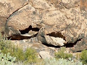
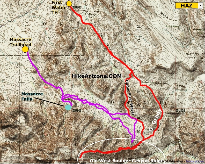
- There isn't a path and there are less than a dozen cairns. (We built all but one of those showing where to climb up and down the peaks. The lone existing cairn seemed to be off route.) - There are only 3 or 4 places where you have to climb any rocks. These are as easy to get up and down as those in the middle part of Siphon Draw. (I could sit down and reach the footholds below me.) - It's mostly light to moderate bushwhacking taking advantage of game trails. I strongly suggest long pants and a shirt. There's not much catclaw but both of us ended up with lots of Prickly Pear thorns in our legs. If you get off the game trails, you could get into heavier bushwhacking. - The lower section is fairly steep with loose rocks over dirt. This is soft aerated soil that can be treacherous when wet. (It rained the day before I planned to make this trip so I waited 5 days for the ground to firm up.) - The most difficult part of the hike is about halfway up, where there's 3/4 mile of the worst scree I've ever run into, going around one of the peaks. Most hikers will find trekking poles necessary or at least useful in navigating this section. (There was a time or two when I unintentionally skied downhill through the scree.) The general route to the top is easy--head basically due west and UP from the end of O'Grady Canyon. Avoid thick vegetation and make your own mini-switchbacks as needed. Take advantage of any game trail that's headed uphill. The only route-finding challenge is deciding whether to go over the top or along the north side of the mini-peaks along the Old West Boulder Canyon ridge. On our route up, we favored the north side trying not to lose altitude on the saddles between the peaks. That wasn't always the right choice. Our route down is the better route. We did not find a good route through the scree. If there is one, it's likely to be lower than either of our routes through this area. My hiking companion tried a higher route on the way up and had to drop back down. The only reason for doing this hike as a back and-forth was trying to find the best route. This is best done paired with another route as part of a loop. Joe's route to the ridgeline from Massacre Falls is an obvious choice. There's no problem doing this route downhill--even the scree is easier when headed downhill. Getting to the base of the hike near the western end of O'Grady canyon requires significant effort. - [GPS Route :: Massacre TH to Old West Boulder Cyn Ridge] You can get there off-trail from Massacre falls and the terrain would be fairly easy except for all the washes coming down from Superstition Mountain. If you stay west close to the mountain, the washes are deep (20 feet or more), sometimes have steep sides, and can be impassible thickets of trees and brush.) - You can get there from the First Water trailhead through Parker pass and then take the O'Grady canyon route past Tim's Saddle. There's a well-defined trail until you pass below and north of Tim's Saddle--past that there are scattered cairns along and near the creek. - You can get there from the First Water trailhead using the off-trail route up the First Water creek bed (the waterfall route). There isn't much difference in time or mileage between the routes. The Parker Pass / O'Grady Canyon route has the least bushwhacking and the least off-trail hiking. The GPS Route for this hike shows us taking the route through Parker Pass and then up O'Grady canyon. On the way back we took the First Water creek route past the waterfall. We got tired of rock-hopping and fighting the catclaw around the creek and bailed out by heading 0.2 miles east cross-country to the Dutchman's trail. It probably wasn't much easier than continuing down the creek.
Check out the Official Route and Triplogs. Note This is a more difficult hike. It would be unwise to attempt this without prior experience hiking. Leave No Trace and +Add a Triplog after your hike to support this local community. | ||||||||||||||||||||||||||||||||||||||||||||||||||||||||||||||||||||||||||||||||||||||||||||||||||||||||||||||||||||||||||||||||||||||||||||||||||||||||||||||||||||||||||||||||||||||||||||||||||||||||||