Parker Lake is a reasonably short hike near the northern end of the June Lake Loop. This area is fairly dry and the terrain leading up to and beyond the trailhead is primarily chaparral. The trailhead heads up steeply to the top of a bluff overlooking Parker Creak. Parker Creek is located in a canyon lined with pine and aspen.
The trail flattens out and eventually so does Parker Creek, running adjacent to the trail. The trail enters into a forest of pine and aspen. The walls of the canyon are still primarily chaparral, but the creek is undoubtedly providing a plenty of water for the surrounding trees.
Further up the trail Parker Creek is clogged with fallen trees. Many if these trees fell, roots included. I don’t know this for a fact, but I suspect that it is due to flooding caused by the snowmelt of 2011. This is the year than Mammoth Mountain, 45 minutes to the south, received a record of nearly 700 inches of snow.
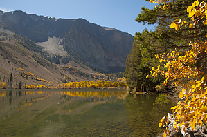
The trail reaches the east end of Parker Lake shortly after Parker Creek bends away from the trail. The views of Parker Lake and the surrounding Peaks are stunning. Don’t expect to be the only one at the lake though. This is a very popular hike.
WARNING! Hiking and outdoor related sports can be dangerous. Be responsible and prepare for the trip. Study the area you are entering and plan accordingly. Dress for the current and unexpected weather changes. Take plenty of water. Never go alone. Make an itinerary with your plan(s), route(s), destination(s) and expected return time. Give your itinerary to trusted family and/or friends.
To hike Take US 395 to the north end of the June Lake Loop. Head south on June Lake Loop and look for the Parker Lake sign less than a mile south of the 395 junction. You’ll leave the pavement here. Follow the road until you reach a sign the shows Parker Lake to the left and Parker Creek straight ahead. Take the left fork. The road dead ends at the Parker Lake parking area.
page created by HAZ_Hikebot on Oct 11 2014 10:29 pm
 Route Editor