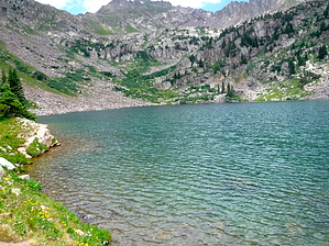
The Pitkin Trail begins in East Vail and ends at Pitkin Lake: The first mile of the trail is strenuous as it climbs steeply out of the Vail Valley. The grade levels out somewhat as the trail passes through mature aspen groves and spruce-fir forests and a series of moraines from an ancient glacial retreat. After about 2.5 miles, steep switchbacks reveal the first of two waterfalls on Pitkin Creek about 200 yards to the east. After a number of false summits, the trail reaches Pitkin Lake, nestled beneath an arc of gray granite in the alpine tundra.
WARNING! Hiking and outdoor related sports can be dangerous. Be responsible and prepare for the trip. Study the area you are entering and plan accordingly. Dress for the current and unexpected weather changes. Take plenty of water. Never go alone. Make an itinerary with your plan(s), route(s), destination(s) and expected return time. Give your itinerary to trusted family and/or friends.
Permit $$
no fees or permits reported
if incorrect tell us about it
Directions
Road
To hike Travel east from Vail on I-70 to Exit 180 for East Vail. Exit here, turn left, and pass under the interstate. Turn right onto the north frontage road and continue to the trailhead on the left side of the road before the Pitkin Creek Townhomes.
page created by HAZ_Hikebot on Mar 10 2010 12:20 am
 Route Editor