Overview: This is a very physical hike which makes a great side excursion from the Pacific Crest Trail and the Tahoe Rim Trail or a short but dramatic day hike to this south shore mountain top with fantastic panoramic views looking over the Crystal Mountain Range, the Desolation Wilderness and Lake Tahoe.
History: The mountain is named for William Chapman Ralston, who made his first millions in the great bonanza of Nevada's Comstock mines. He went on to become one of the richest and most powerful men in California, co-founding the Bank of California. He supported the common man's ambitions and was noted to loan people money based on their character. His financial empire collapsed in 1873 in part due to the "Panic of 1873", a great depression.
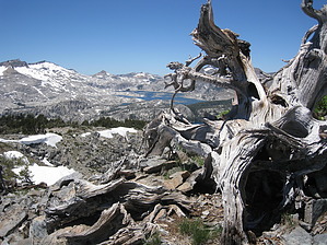
Hike: All hikes into the Desolation Wilderness require a permit. Day hike permits are free and are available at this trailhead. Overnight stays require you to check in at a local forest service facility and pay a fee. The trailhead is directly across the street from Camp Sacramento. There is a sign on the north side of the road and you can park here or take the rough gravel road about 250 yards north to a formal trailhead with a kiosk and self service permits. There is only room for about five cars so you may have to park below by the highway. The trail is all work right from the start. Whoever designed this trail used his budget of switchbacks on the initial two miles, then got anxious and went straight up. The trail starts off very easy to follow and meets another unmarked trail coming up from a private camp off to the right at about one half mile. Remember this on your way back. The trail levels off momentarily at .85 miles as you have gained the initial 450'. Getting steeper now there are a couple sections where you use hands and feet over some granite boulders. A creek can be heard off to the right. This is Tamarack Creek. It is never in sight if you stay on the trail and it is a steep climb down to try to see it. A short time later you hear the roar of Pyramid Creek off to your left. Again you will not see it. The trail follows the inner contour of the mountain and every time you see blue ahead thinking you will get some nice views, the trail turns inward. The trail is locked into a thick deep forest of pines and firs and you become anxious for some distant views. The forest finally thins offering distant views to the south of a slope cleared and used for skiing. At 2.35 miles the trail reaches a saddle offering views to the north and west including Pyramid Peak. Catch your breath here and look for cairns. If you look to the right you will see a single track trail going straight up the mountain. This is your place to turn onto that trail. If you find yourself, distracted by the beauty of Pyramid peak on your left, continuing on and descending you have missed the turn. The trail gets very steep now with a direct line up. For the first time cairns start to appear and are necessary. The terrain gets rockier and eventually you are threading in, on and around boulders. As long as you are going straight up you are fine as you can always spot a cairn above and ahead. The high point ahead finally comes into view although this is not the peak. Circle left at the base of the rock pile and work your way over to the top of the cirque that looks down onto the many lakes below. Now off to the right you see your ultimate destination, Ralston Peak. Watch for the many Yellow-Bellied Marmots that occupy this rocky area. Follow the top of the cirque to the peak and enjoy the views you have anticipated. The peak has very comfortable sitting rocks and you will savor the time you spend here. Having your fill, return the way you came.
When hiking several trails on a single "hike", log it with a generic name that describes the hike. Then link the trails traveled, check out the example.
WARNING! Hiking and outdoor related sports can be dangerous. Be responsible and prepare for the trip. Study the area you are entering and plan accordingly. Dress for the current and unexpected weather changes. Take plenty of water. Never go alone. Make an itinerary with your plan(s), route(s), destination(s) and expected return time. Give your itinerary to trusted family and/or friends.
Permit $$
information is in description
Directions
Road
FR / Dirt Road / Gravel - Car Okay
To hike From South Lake Tahoe take Hwy 50 west of Hwy 89 climb the grade up to Echo Pass then continue 5.5 miles to the marked trailhead on your right. Permits are required and can be obtained free of charge at the trailhead.
 Route Editor


