Route Editor

| Guide | ♦ | 11 Triplogs | 0 Topics |
details | drive | permit | forecast | route |
stats |
photos | triplogs | topics | location |
| 105 | 11 | 0 |
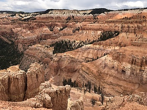
Bryce Canyon without the crowds by LindaAnn Moderate hike along the southern rim of the Cedar Breaks amphitheater. Views are similar to Bryce Canyon, but the amphitheater is more than twice as deep as Bryce. Visitation is a small fraction of the Bryce crowds, which allows for more opportunities to see wildlife. Warning There are no guardrails along most of the rim edge. Use caution at the edge, as the trail surface can be slippery. Avoid standing on the rim when lightning is nearby.
The trail starts at the western side of the main parking area, south of the restrooms. Head west on the trail and up a short slope. At the top of the slope, the view of the amphitheater spreads out below you. Snap a picture, then head south on the trail where even better views await. The trail heads south along the edge of the rim, gradually turning southwest and heading uphill towards a water tank perched on the high point of the trail. Along the way, there is a very short spur trail to you left that heads over to a old cabin. There used to be a lodge at this location, but it was torn down decades ago, the cabin is all that remains. Once back on the main trail, continue heading southwest. During the summer, wildflowers abound along this section of the trail. Once past the water tank, the trail descends and heads northwest towards Spectra Viewpoint. There are numerous Bristlecone Pines around Spectra Viewpoint, with some signs detailing their history. Many people turn around at Spectra, which makes for a hike of 2 miles and 360' aeg. If you choose to continue, head west on the main trail, which quickly starts to switchback downhill. At the start of the switchbacks, which run along Shooting Star Creek, keep an eye out for marmots, which are frequently seen along the rest of the trail. The trail runs alongside and above the creek for a while, slightly further from the edge of the rim, but you will still get plenty of great views. After just under another mile from Spectra Point, the trail forks just before reaching Ramparts Viewpoint. Take the right fork to head up to the viewpoint, then come back down to the fork and take the left fork to continue west on the trail. There are no signs on the trail after this point. Continuing west, the trail continues downhill through the forest and views are limited for a while. There are numerous spots where the trail is just beneath the edge of the rim, and veering a few feet off the trail to peek over the edge will give you plenty of views. Nearing the The Bartizen, which is the final viewpoint, the trail leaves the trees and heads across the brightly colored orange clay hillsides. There's also white, yellow, and pink clay mixed throughout, and the variety of color is quite stunning. You'll notice a fragile looking double window in the rocks to the left of the viewpoint. The viewpoint is wide and flat, facing west, but does not have views of the main amphitheater, and seems to be the end of the official trail. However, there is a well worn use trail heading north and uphill from the viewpoint, and if you have hiked this far, it is well worth the additional fine minutes of walking to the top of this hill. The use trail is generally easy as it heads uphill and in front of some boulders. Just above the boulders, there's about fifteen feet of steeper trail, then the incline becomes easy again. Once at the top after a short distance, views of nearly the entire amphitheater appear with some of the best views of the hike. After your fill of pictures, retrace your steps to the parking lot on the same trail. The return trip most of the elevation gain on the hike, which you will be very aware of at an elevation of 10,000', so be prepared. Take your time, and enjoy the views on your return hike. Check out the Official Route and Triplogs. Leave No Trace and +Add a Triplog after your hike to support this local community. | ||||||||||||||||||||||||||||||||||||||||||||||||||||||||||||||||||||||||||||||||||||||||||||||||