 Route Editor

| Guide | ♦ | 1 Triplog | 0 Topics |
details | drive | no permit | forecast | route |
stats |
photos | triplog | topics | location |
| 14 | 1 | 0 |
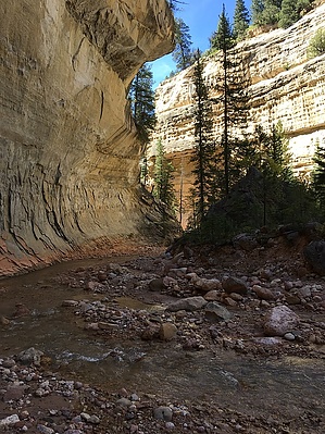
off the rim by toddak Starting just north of Cedar Breaks National Monument, this excellent route follows a good trail through alpine forest and along Rattlesnake Creek, then transitions to off-trail creek hiking down narrow Ashdown Creek. Typically done in the downhill direction with a roughly 20-mile shuttle. Warning Swift, cold current during Spring runoff. Flash flooding possible in Summer.
Leave the Cedar Breaks crowds behind and head west on the signed Rattlesnake trail into the thick forest and begin descending. There are two short spur trails to the left that give great views into the Cedar Breaks amphitheater. Continuing steeply downhill several miles through forest and meadows brings you to Rattlesnake Creek and, eventually the signed junction with High Mountain Trail. Here the route leaves the Rattlesnake Creek drainage and contours around and down into the Ashdown Creek drainage. Once down to the creek, leave the trail, put on your wool or neoprene socks, and head downstream for roughly 3.5 miles of easy canyoneering in a gorgeous canyon (you'll be crossing the creek innumerable times, no more than shin-deep during non-runoff times). Along the way, you'll see Tom's Head, a large freestanding pillar where Rattlesnake Creek joins Ashdown - head up this drainage a half-mile or so to a split and continue up both forks a short distance to lovely waterfalls. Back in Ashdown, continue downstream, keeping an eye out for Flanagan's Arch high on the right wall. Eventually, the canyon opens up, and Highway 14 comes into view - stay down in the creek as it parallels the highway until an easy scramble takes you up to a small dirt parking area along the highway at mile mark 7 and your shuttle vehicle. Camping Several good campsites along Rattlesnake Creek and where the route joins Ashdown Creek. Check out the Official Route and Triplog. Leave No Trace and +Add a Triplog after your hike to support this local community. One-Way Notice This hike is listed as One-Way. When hiking several trails on a single "hike", log it with a generic name that describes the hike. Then link the trails traveled, check out the example. | ||||||||||||||||||||||||||||||||||||||||||||||||||||||||||||||||||||||||||||||||||||||||||||


